IMAGES TAKEN NEAR TO
Mallard Avenue, LEICESTER, LE6 0GR
Introduction
This page details the photographs taken nearby to Mallard Avenue, LE6 0GR by members of the Geograph project.
The Geograph project started in 2005 with the aim of publishing, organising and preserving representative images for every square kilometre of Great Britain, Ireland and the Isle of Man.

There are currently over 7.5m images from over14,400 individuals and you can help contribute to the project by visiting https://www.geograph.org.uk
Image Map
Images are licensed for reuse under creativecommons.org/licenses/by-sa/2.0
Notes
- Clicking on the map will re-center to the selected point.
- The higher the marker number, the further away the image location is from the centre of the postcode.
Image Listing (14 Images Found)
Images are licensed for reuse under creativecommons.org/licenses/by-sa/2.0
Image
Details
Distance
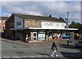
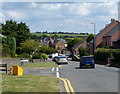
3
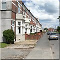
Victoria Terrace, Groby
Located along Ratby Road in Groby.
Image: © Mat Fascione
Taken: 7 Jul 2007
0.16 miles
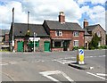
6
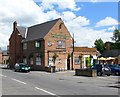
The Stamford Arms, Groby
Public House at the junction of Ratby Road and Leicester Road.
Image: © Mat Fascione
Taken: 7 Jul 2007
0.20 miles
7
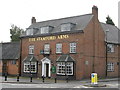
Groby Stamford Arms
2 Leicester Road. Everards pub, Grade II listed building.
Image: © the bitterman
Taken: 19 Sep 2010
0.21 miles
9
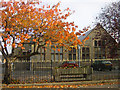
Groby Village Hall
View the Village web site for further details - www.groby.org.uk
Image: © Mike Pratt
Taken: Unknown
0.22 miles
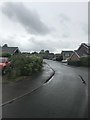
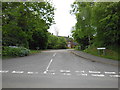
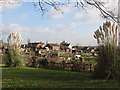
10
Road junction in Groby
The junction of Ratby Road, Markfield Road and Leicester Road.
Image: © Mat Fascione
Taken: 7 Jul 2007
0.23 miles