IMAGES TAKEN NEAR TO
Lena Drive, LEICESTER, LE6 0FJ
Introduction
This page details the photographs taken nearby to Lena Drive, LE6 0FJ by members of the Geograph project.
The Geograph project started in 2005 with the aim of publishing, organising and preserving representative images for every square kilometre of Great Britain, Ireland and the Isle of Man.

There are currently over 7.5m images from over14,400 individuals and you can help contribute to the project by visiting https://www.geograph.org.uk
Image Map
Images are licensed for reuse under creativecommons.org/licenses/by-sa/2.0
Notes
- Clicking on the map will re-center to the selected point.
- The higher the marker number, the further away the image location is from the centre of the postcode.
Image Listing (8 Images Found)
Images are licensed for reuse under creativecommons.org/licenses/by-sa/2.0
Image
Details
Distance
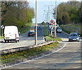
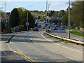
1
Speed camera along the A50 Markfield Road
Image: © Mat Fascione
Taken: 8 Feb 2015
0.11 miles
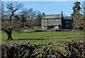
4
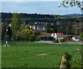
Farmland on the edge of Groby
The houses are along the A50 Markfield Road.
Image: © Mat Fascione
Taken: 15 Apr 2014
0.17 miles
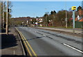
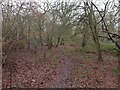
5
Slate Pit Lane in Groby
This lane runs between the A50 Markfield Road and Groby Lodge Farm.
Image: © Mat Fascione
Taken: 19 Jan 2014
0.23 miles