IMAGES TAKEN NEAR TO
Willow Drive, LEICESTER, LE6 0EL
Introduction
This page details the photographs taken nearby to Willow Drive, LE6 0EL by members of the Geograph project.
The Geograph project started in 2005 with the aim of publishing, organising and preserving representative images for every square kilometre of Great Britain, Ireland and the Isle of Man.

There are currently over 7.5m images from over14,400 individuals and you can help contribute to the project by visiting https://www.geograph.org.uk
Image Map
Images are licensed for reuse under creativecommons.org/licenses/by-sa/2.0
Notes
- Clicking on the map will re-center to the selected point.
- The higher the marker number, the further away the image location is from the centre of the postcode.
Image Listing (8 Images Found)
Images are licensed for reuse under creativecommons.org/licenses/by-sa/2.0
Image
Details
Distance
1

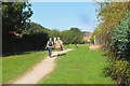
Path south of Groby
A relatively new path on the route of a former railway, linking with the Ivanhoe Trail to Ratby.
Image: © Jim Barton
Taken: 14 Sep 2019
0.06 miles
2
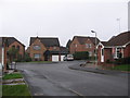
Housing, Oak Meadow Lane, Groby
Viewed from Queensmead Close
Image: © Tammy Winand
Taken: 14 Jan 2006
0.09 miles
3
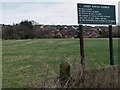
Groby Parish Council sign
Located along Sacheverell Way in Groby.
Image: © Mat Fascione
Taken: 8 Mar 2009
0.10 miles
6

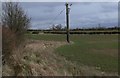
Footpath across farmland near Groby
The rape crop is not ready for harvesting
Image: © John Welford
Taken: 26 Jul 2016
0.23 miles
7

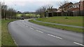
Laundon Way's Co-op, Groby
A local supermarket in the residential area.
Image: © Jim Barton
Taken: 14 Sep 2019
0.23 miles
8
Path by recreation field, Groby
A green space in the residential area of Groby.
Image: © Jim Barton
Taken: 14 Sep 2019
0.24 miles