IMAGES TAKEN NEAR TO
Castell Drive, LEICESTER, LE6 0DE
Introduction
This page details the photographs taken nearby to Castell Drive, LE6 0DE by members of the Geograph project.
The Geograph project started in 2005 with the aim of publishing, organising and preserving representative images for every square kilometre of Great Britain, Ireland and the Isle of Man.

There are currently over 7.5m images from over14,400 individuals and you can help contribute to the project by visiting https://www.geograph.org.uk
Image Map
Images are licensed for reuse under creativecommons.org/licenses/by-sa/2.0
Notes
- Clicking on the map will re-center to the selected point.
- The higher the marker number, the further away the image location is from the centre of the postcode.
Image Listing (14 Images Found)
Images are licensed for reuse under creativecommons.org/licenses/by-sa/2.0
Image
Details
Distance
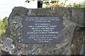
3
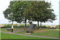
Stamford Memorial Park, Groby
The granite memorial commemorates five young men, members of the Stamford Arms football team, who died in a road accident in December 1998. There are also five benches nearby, named for each.
Image: © Jim Barton
Taken: 15 Sep 2019
0.19 miles
4
Memorial stone, Stamford Memorial Park Groby
A closer view of the memorial shown in Image
Image: © Jim Barton
Taken: 15 Sep 2019
0.20 miles
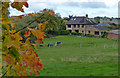
5
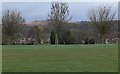
View towards Bradgate Park
A recreation ground and some houses in Groby in the foreground.
Image: © Mat Fascione
Taken: 8 Mar 2009
0.20 miles

8
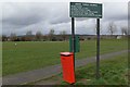
Recreation ground in Groby
Located along Sacheverell Way.
Image: © Mat Fascione
Taken: 8 Mar 2009
0.22 miles