IMAGES TAKEN NEAR TO
Johnscliffe Close, LEICESTER, LE6 0AT
Introduction
This page details the photographs taken nearby to Johnscliffe Close, LE6 0AT by members of the Geograph project.
The Geograph project started in 2005 with the aim of publishing, organising and preserving representative images for every square kilometre of Great Britain, Ireland and the Isle of Man.

There are currently over 7.5m images from over14,400 individuals and you can help contribute to the project by visiting https://www.geograph.org.uk
Image Map
Images are licensed for reuse under creativecommons.org/licenses/by-sa/2.0
Notes
- Clicking on the map will re-center to the selected point.
- The higher the marker number, the further away the image location is from the centre of the postcode.
Image Listing (24 Images Found)
Images are licensed for reuse under creativecommons.org/licenses/by-sa/2.0
Image
Details
Distance
3
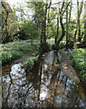
River Lin in Newtown Linford
Next to the junction of Markfield Lane and the Main Street.
Image: © Mat Fascione
Taken: 8 May 2020
0.10 miles
5
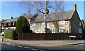
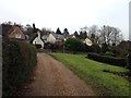
Newtown Linford Leicestershire
Cottages at the corner of Main Street and Grey Crescent.
Image: © Mat Fascione
Taken: 5 Apr 2007
0.10 miles
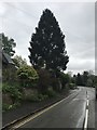
6

The Linford, Newtown Linford
A members club pub close to the original ford over the River Lin
Image: © Tim Heaton
Taken: 4 Jan 2019
0.13 miles
8
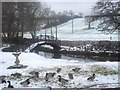
Mallards on the River Lyn at Chiangmai Newtown Linford
Image: © Pam A McMorran
Taken: 27 Dec 2005
0.14 miles
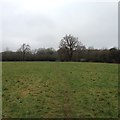
10
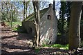
Ulverscroft Mill
Overgrown and ruinous 19th C mill. Probably a one man mill like at Mortimer's Cross. Image]
Image: © Ashley Dace
Taken: 5 May 2013
0.17 miles