IMAGES TAKEN NEAR TO
St. Saviours Road, LEICESTER, LE5 4HJ
Introduction
This page details the photographs taken nearby to St. Saviours Road, LE5 4HJ by members of the Geograph project.
The Geograph project started in 2005 with the aim of publishing, organising and preserving representative images for every square kilometre of Great Britain, Ireland and the Isle of Man.

There are currently over 7.5m images from over14,400 individuals and you can help contribute to the project by visiting https://www.geograph.org.uk
Image Map (Loading...)


Getting Data...Please wait
Leaflet Map data © OpenStreetMap
Images are licensed for reuse under creativecommons.org/licenses/by-sa/2.0
Notes
- Clicking on the map will re-center to the selected point.
- The higher the marker number, the further away the image location is from the centre of the postcode.
Image Listing (8 Images Found)
Images are licensed for reuse under creativecommons.org/licenses/by-sa/2.0
Image
Details
Distance
1
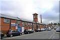
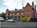
Former Faraday Works, St Saviour's Road, Leicester
"The factory was built circa 1898, and designed by the locally and regionally important Arthur Wakerely; a former architect, surveyor and city mayor of Leicester. The building is best known as the factory of Gents and Company Limited, a manufacturing company known for producing electrical equipment." (Leicester City Local Heritage Asset Register).
Now occupied by clothing manufacturers.
Image: © Tim Heaton
Taken: 6 Oct 2020
0.03 miles
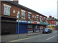
2
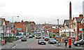
St Saviours Road, North Evington, Leicester
An eclectic mix of housing styles together with old and modern industrial works.
Image: © Kate Jewell
Taken: 21 Dec 2005
0.09 miles
3
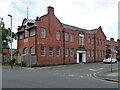
Wycliffe Hall, Gwendolen Road, Leicester
Built in 1905 by Arthur Wakerley, a prominent local architect and builder. The suburb of North Evington was developed by him as a model industrial settlement. Grade II listed.
Image: © Stephen Richards
Taken: 24 Jun 2015
0.18 miles
4
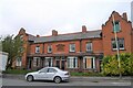
Hunter Lodge, Gwendolen Road, Leicester
Grade II listed row of houses https://historicengland.org.uk/listing/the-list/list-entry/1389422.
Tablet in centre reads: "Erected by the Wycliffe Society for helping the blind. On site presented during his mayorality by alderman Arthur Wakerley, 1897-98".
Now a Care Home.
Image: © Tim Heaton
Taken: 6 Oct 2020
0.20 miles
5
138 Gwendolen Road, Leicester
Built as the Wycliffe Society Cottage Homes for the Blind in 1895 by Arthur Wakerley, a prominent local architect and builder. The suburb of North Evington was developed by him as a model industrial settlement. Grade II listed.
Image: © Stephen Richards
Taken: 24 Jun 2015
0.21 miles
7
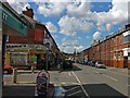
St Saviour's Road in North Evington, Leicester
At the junction with Osborne Road.
Image: © Mat Fascione
Taken: 17 Aug 2017
0.23 miles
8
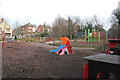
Playground on Gwendolen Road, Leicester
School holidays but this playground next to Coleman Primary School was empty!
Image: © Kate Jewell
Taken: 21 Dec 2005
0.24 miles