IMAGES TAKEN NEAR TO
Coleman Road, LEICESTER, LE5 4AJ
Introduction
This page details the photographs taken nearby to Coleman Road, LE5 4AJ by members of the Geograph project.
The Geograph project started in 2005 with the aim of publishing, organising and preserving representative images for every square kilometre of Great Britain, Ireland and the Isle of Man.

There are currently over 7.5m images from over14,400 individuals and you can help contribute to the project by visiting https://www.geograph.org.uk
Image Map (Loading...)


Getting Data...Please wait
Leaflet Map data © OpenStreetMap
Images are licensed for reuse under creativecommons.org/licenses/by-sa/2.0
Notes
- Clicking on the map will re-center to the selected point.
- The higher the marker number, the further away the image location is from the centre of the postcode.
Image Listing (21 Images Found)
Images are licensed for reuse under creativecommons.org/licenses/by-sa/2.0
Image
Details
Distance
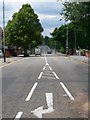
2
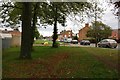
Trees along Coleman Road in North Evington
Image: © Mat Fascione
Taken: 13 Oct 2017
0.04 miles
4
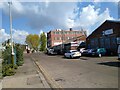
Tithe Street
The eastern side of the street looking towards Bushby Brook. The area to the left of this photo has very recently been redeveloped into housing.
Image: © Pierre Marshall
Taken: 2 May 2021
0.12 miles
5
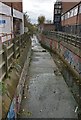
Bushby Brook in North Evington, Leicester
Looking west from Coleman Road.
Image: © Mat Fascione
Taken: 13 Oct 2017
0.13 miles
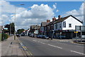
8
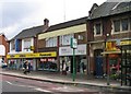
Lord's and Loros
Shops on Uppingham Road.
Image: © Andrew Tatlow
Taken: 13 Aug 2010
0.14 miles