IMAGES TAKEN NEAR TO
London Street, LEICESTER, LE5 3RW
Introduction
This page details the photographs taken nearby to London Street, LE5 3RW by members of the Geograph project.
The Geograph project started in 2005 with the aim of publishing, organising and preserving representative images for every square kilometre of Great Britain, Ireland and the Isle of Man.

There are currently over 7.5m images from over14,400 individuals and you can help contribute to the project by visiting https://www.geograph.org.uk
Image Map (Loading...)


Getting Data...Please wait
Leaflet Map data © OpenStreetMap
Images are licensed for reuse under creativecommons.org/licenses/by-sa/2.0
Notes
- Clicking on the map will re-center to the selected point.
- The higher the marker number, the further away the image location is from the centre of the postcode.
Image Listing (33 Images Found)
Images are licensed for reuse under creativecommons.org/licenses/by-sa/2.0
Image
Details
Distance
1
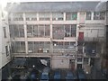
Garment factories
Workshops in the old Imperial Typewriters building, taken through a window in one of the stairways.
Image: © Pierre Marshall
Taken: 12 Apr 2021
0.04 miles
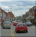
2
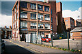
Warehouse on Nottingham Road
Multi-storey industrial building photographed on a sunny day. I can't remember if 18th April was the exact date, it was definitely a Sunday morning.
Image: © Pierre Marshall
Taken: 18 Apr 2021
0.05 miles
3
Warehouse on Nottingham Road
Multi-storey industrial building.
Image: © Pierre Marshall
Taken: 22 Sep 2020
0.05 miles
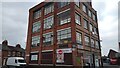
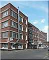
4
70 Rolleston Street, Leicester
Inter-war factory now sub-divided, and mostly associated with the clothing industry.
Image: © Stephen Richards
Taken: 24 Jun 2015
0.05 miles
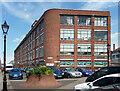
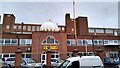
5
Imperial Buildings, East Park Road, Leicester
Once the factory of the Imperial Typewriters Company and so putting on a bit of show, although later alterations have hardly been respectful.
Now sub-divided for a variety of uses.
Image: © Stephen Richards
Taken: 24 Jun 2015
0.06 miles
6
Guru Tegh Bahadur Gurudwara
Big Gurdwara on Rosebery Street. I don't know how to describe this architectural style - it looks like a boxy school building.
Image: © Pierre Marshall
Taken: 14 Mar 2021
0.07 miles
7
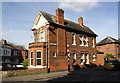
#1 Nottingham Road at St Saviour's Road junction
There is an OS benchmark Image on the near corner of the house at its junction with a brick wall, right of a lamppost
Image: © Roger Templeman
Taken: 4 May 2017
0.11 miles
8
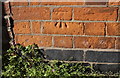
Benchmark on #1 Nottingham Road (St Saviour's Road face)
Ordnance Survey cut mark benchmark described on the Bench Mark Database at https://www.bench-marks.org.uk/bm84280
Image: © Roger Templeman
Taken: 4 May 2017
0.11 miles
10
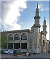
Jame Mosque on Asfordby Street, Leicester
Image: © Mat Fascione
Taken: 31 Oct 2018
0.12 miles