IMAGES TAKEN NEAR TO
Halstead Street, LEICESTER, LE5 3RD
Introduction
This page details the photographs taken nearby to Halstead Street, LE5 3RD by members of the Geograph project.
The Geograph project started in 2005 with the aim of publishing, organising and preserving representative images for every square kilometre of Great Britain, Ireland and the Isle of Man.

There are currently over 7.5m images from over14,400 individuals and you can help contribute to the project by visiting https://www.geograph.org.uk
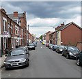
Image Map (Loading...)


Getting Data...Please wait
Leaflet Map data © OpenStreetMap
Images are licensed for reuse under creativecommons.org/licenses/by-sa/2.0
Notes
- Clicking on the map will re-center to the selected point.
- The higher the marker number, the further away the image location is from the centre of the postcode.
Image Listing (45 Images Found)
Images are licensed for reuse under creativecommons.org/licenses/by-sa/2.0
Image
Details
Distance
1
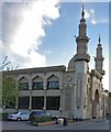
Jame Mosque on Asfordby Street, Leicester
Image: © Mat Fascione
Taken: 31 Oct 2018
0.05 miles
2
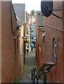
Steps and alleyway leading to Halstead Street
In the inner city area of Spinney Hills, Leicester.
Image: © Mat Fascione
Taken: 2 Aug 2019
0.07 miles
3
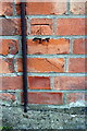
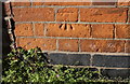
Benchmark on #1 Halstead Street
Ordnance Survey cut mark benchmark described on the Bench Mark Database at https://www.bench-marks.org.uk/bm84405
Image: © Roger Templeman
Taken: 4 May 2017
0.07 miles
5
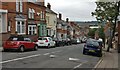
Wood Hill in Spinney Hills, Leicester
Spinney Hills is an inner city area of Leicester.
Image: © Mat Fascione
Taken: 26 Jun 2019
0.08 miles
6
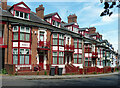
St Saviour's Road, Leicester
Colourful Victorian terrace, each house named after a historical/mythological figure. Those visible here include Nancy, Vigil, Cynthia, Plato, and others include Thetis, Zeus, Minerva, Olympus, Thespian, Osborne.
See also Image
Image: © Stephen Richards
Taken: 24 Jun 2015
0.08 miles
7

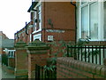
Houses of St Saviour's Road at Halstead Street junction
There is an OS benchmark Image on the corner of the nearest house, on its right hand face and right of cabinet
Image: © Roger Templeman
Taken: 4 May 2017
0.08 miles
8
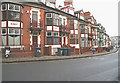
St Saviour's Road, Spinney Hills, Leicester
Opposite the north entrance to Spinney Hill Park. Every house in this 1890's terrace, built by the architect and developer Arthur Wakerley between Halstead Street and Asfordby Street, has a name relating to characters in Greek mythology. See https://www.leicester.gov.uk/planning-and-building/conservation/heritage-conservation/conservation-areas/spinney-hill-park/ for details of this conservation area comprising the park facing houses and the park itself. A downloadable pdf guide to the park is available here: https://www.leicester.gov.uk/leisure-and-culture/parks-and-open-spaces/our-parks/spinney-hill-park/
Image: © Kate Jewell
Taken: 21 Dec 2005
0.08 miles
9
Benchmark on #1 Nottingham Road (St Saviour's Road face)
Ordnance Survey cut mark benchmark described on the Bench Mark Database at https://www.bench-marks.org.uk/bm84280
Image: © Roger Templeman
Taken: 4 May 2017
0.08 miles