IMAGES TAKEN NEAR TO
Haven Walk, LEICESTER, LE5 2LN
Introduction
This page details the photographs taken nearby to Haven Walk, LE5 2LN by members of the Geograph project.
The Geograph project started in 2005 with the aim of publishing, organising and preserving representative images for every square kilometre of Great Britain, Ireland and the Isle of Man.

There are currently over 7.5m images from over14,400 individuals and you can help contribute to the project by visiting https://www.geograph.org.uk
Image Map (Loading...)


Getting Data...Please wait
Leaflet Map data © OpenStreetMap
Images are licensed for reuse under creativecommons.org/licenses/by-sa/2.0
Notes
- Clicking on the map will re-center to the selected point.
- The higher the marker number, the further away the image location is from the centre of the postcode.
Image Listing (6 Images Found)
Images are licensed for reuse under creativecommons.org/licenses/by-sa/2.0
Image
Details
Distance
1
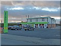
James Coles Plant Nursery, Thurnby, Leicester
On the main A47 at the corner of Uppingham Road and Station Road, this large commercial nursery and garden centre occupies a large proportion of this square. The building with the green roof, centre left, is the Swallow public house.
Image: © Kate Jewell
Taken: 5 Jan 2006
0.23 miles
2
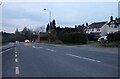
The co-operative store along Station Road
The former Swallow Inn public house.
Image: © Mat Fascione
Taken: 9 Dec 2012
0.23 miles
3
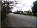
Thurncourt Road in Thurnby Lodge, Leicester
Image: © Mat Fascione
Taken: 9 Dec 2019
0.23 miles
4
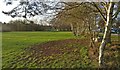
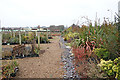
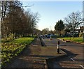
Recreation ground in Thurnby Lodge, Leicester
The recreation ground is between Thurncourt Road and the Bushby Brook.
Image: © Mat Fascione
Taken: 9 Dec 2019
0.23 miles