IMAGES TAKEN NEAR TO
Sextant Road, LEICESTER, LE5 2JA
Introduction
This page details the photographs taken nearby to Sextant Road, LE5 2JA by members of the Geograph project.
The Geograph project started in 2005 with the aim of publishing, organising and preserving representative images for every square kilometre of Great Britain, Ireland and the Isle of Man.

There are currently over 7.5m images from over14,400 individuals and you can help contribute to the project by visiting https://www.geograph.org.uk
Image Map
Images are licensed for reuse under creativecommons.org/licenses/by-sa/2.0
Notes
- Clicking on the map will re-center to the selected point.
- The higher the marker number, the further away the image location is from the centre of the postcode.
Image Listing (11 Images Found)
Images are licensed for reuse under creativecommons.org/licenses/by-sa/2.0
Image
Details
Distance
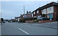
1
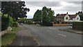
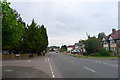
Scraptoft Lane in Leicester
At the junction with Wigley Road.
Image: © Mat Fascione
Taken: 24 Jul 2017
0.06 miles
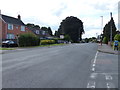
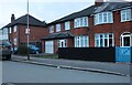
9
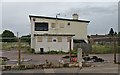
Former Mayflower pub
On the corner of Gervas Road and Ocean Road, in the Thurnby Lodge area of Leicester. It was built by Ansells in 1957, and closed in 2018.
Image: © Mat Fascione
Taken: 4 Sep 2020
0.22 miles
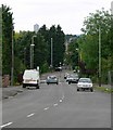
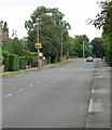
10
Scraptoft Lane at the junction with Brook Road, Scraptoft
Image: © Tim Heaton
Taken: 10 Jul 2019
0.23 miles