IMAGES TAKEN NEAR TO
Uppingham Road, LEICESTER, LE5 2BF
Introduction
This page details the photographs taken nearby to Uppingham Road, LE5 2BF by members of the Geograph project.
The Geograph project started in 2005 with the aim of publishing, organising and preserving representative images for every square kilometre of Great Britain, Ireland and the Isle of Man.

There are currently over 7.5m images from over14,400 individuals and you can help contribute to the project by visiting https://www.geograph.org.uk
Image Map
Images are licensed for reuse under creativecommons.org/licenses/by-sa/2.0
Notes
- Clicking on the map will re-center to the selected point.
- The higher the marker number, the further away the image location is from the centre of the postcode.
Image Listing (13 Images Found)
Images are licensed for reuse under creativecommons.org/licenses/by-sa/2.0
Image
Details
Distance
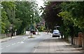
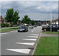
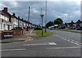
3
Uppingham Road (A47) at Colchester Road
Image: © Peter Whatley
Taken: 28 Jul 2013
0.06 miles
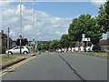
5
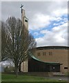
St Joseph's Church in Leicester
This Catholic church was designed by architect Tom Wilson and opened in 1968.
It is on the corner of the A47 Uppingham Road and Goodwood Road.
Image: © Mat Fascione
Taken: 3 Apr 2020
0.10 miles
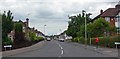
6
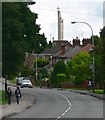
A47 Uppingham Road, Leicester
St Josephs Church is visible in the background.
Image: © Mat Fascione
Taken: 17 Jun 2007
0.10 miles
7
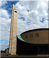
St Joseph's Church in Leicester
On the corner of the A47 Uppingham Road and Goodwood Road.
Image: © Mat Fascione
Taken: 9 Aug 2014
0.11 miles

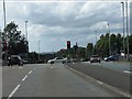
9
Junction of Elmcroft Avenue and the A563
Image: © Mat Fascione
Taken: 9 Aug 2014
0.17 miles