IMAGES TAKEN NEAR TO
Shepherd Close, LEICESTER, LE5 1NU
Introduction
This page details the photographs taken nearby to Shepherd Close, LE5 1NU by members of the Geograph project.
The Geograph project started in 2005 with the aim of publishing, organising and preserving representative images for every square kilometre of Great Britain, Ireland and the Isle of Man.

There are currently over 7.5m images from over14,400 individuals and you can help contribute to the project by visiting https://www.geograph.org.uk
Image Map
Images are licensed for reuse under creativecommons.org/licenses/by-sa/2.0
Notes
- Clicking on the map will re-center to the selected point.
- The higher the marker number, the further away the image location is from the centre of the postcode.
Image Listing (7 Images Found)
Images are licensed for reuse under creativecommons.org/licenses/by-sa/2.0
Image
Details
Distance
1
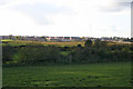
Hamilton, near Leicester
Looking SW across the square towards the new urban development of Hamilton. This is farmland at risk of disappearing
Image: © Kate Jewell
Taken: 9 Nov 2005
0.12 miles
2
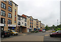
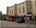
the eye clinic and other shops at Hamilton
Image: © Andrew Tatlow
Taken: 13 Jun 2016
0.18 miles
3
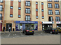
Hamilton Pharmacy + Oh My God at Hamilton
Image: © Andrew Tatlow
Taken: 13 Jun 2016
0.20 miles
4
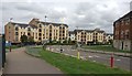
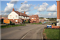
Sandhills Avenue in Hamilton, Leicester
Hamilton is a rapidly expanding suburb on the northeastern edge of Leicester.
Image: © Mat Fascione
Taken: 20 Aug 2018
0.20 miles
6
Hamilton, near Leicester
A large residential development, Hamilton is located in the north-east of Leicester and is one of two major ‘Urban Extensions’ in the City. The other is Ashton Green, not yet built but planned for the fields here:Image
Image: © Kate Jewell
Taken: 9 Nov 2005
0.22 miles
7
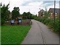
Hamilton, Leicester
New housing estate on the northeast edge of Leicester.
Image: © Mat Fascione
Taken: 16 Jul 2007
0.22 miles