IMAGES TAKEN NEAR TO
New Romney Crescent, LEICESTER, LE5 1NL
Introduction
This page details the photographs taken nearby to New Romney Crescent, LE5 1NL by members of the Geograph project.
The Geograph project started in 2005 with the aim of publishing, organising and preserving representative images for every square kilometre of Great Britain, Ireland and the Isle of Man.

There are currently over 7.5m images from over14,400 individuals and you can help contribute to the project by visiting https://www.geograph.org.uk
Image Map
Images are licensed for reuse under creativecommons.org/licenses/by-sa/2.0
Notes
- Clicking on the map will re-center to the selected point.
- The higher the marker number, the further away the image location is from the centre of the postcode.
Image Listing (20 Images Found)
Images are licensed for reuse under creativecommons.org/licenses/by-sa/2.0
Image
Details
Distance
2
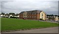
Aaron Court Care Home in Netherhall, Leicester
Constructed on the site of the former Golden Age public house.
Image, taken nearly 5 years earlier.
Image: © Mat Fascione
Taken: 14 Aug 2017
0.10 miles
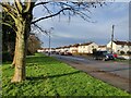
3

Construction work at Briarfield Drive
On the site of the former Golden Age public house, in Ramsay Way, Netherhall.
Image, same view taken nearly 5 years later.
Image: © Mat Fascione
Taken: 9 Dec 2012
0.10 miles
4
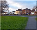
New Romney Crescent in Nether Hall, Leicester
Image: © Mat Fascione
Taken: 2 Jan 2021
0.10 miles
5
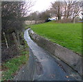
Scraptoft Brook
Flowing alongside New Romney Crescent in Nether Hall.
Image: © Mat Fascione
Taken: 9 Dec 2012
0.11 miles
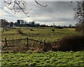
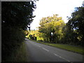
7
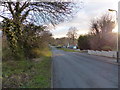
Hamilton Lane in Nether Hall
Heading south towards Scraptoft.
Image: © Mat Fascione
Taken: 9 Dec 2012
0.14 miles
8
New Romney Crescent approaching Hamilton Lane, Leicester
Hamilton Lane forms the Leicester city boundary; beyond is Harborough District
Image: © Tim Heaton
Taken: 10 Jul 2019
0.15 miles
9
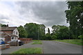
Hamilton Lane, Nether Hall
The eastern edge of Nether Hall (and of the Leicester built up area) is bounded by Hamilton Lane, seen at its junction with New Romney Crescent (left).
Image: © Richard Vince
Taken: 13 Oct 2012
0.15 miles
10
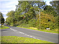
Hamilton Lane north of Scraptoft
Looking north from near the fringe of Scraptoft village, towards Nether Hall. Confusingly, the Scraptoft village sign (right) is double sided.
Image: © Richard Vince
Taken: 13 Oct 2012
0.16 miles