IMAGES TAKEN NEAR TO
Keyham Lane, LEICESTER, LE5 1FG
Introduction
This page details the photographs taken nearby to Keyham Lane, LE5 1FG by members of the Geograph project.
The Geograph project started in 2005 with the aim of publishing, organising and preserving representative images for every square kilometre of Great Britain, Ireland and the Isle of Man.

There are currently over 7.5m images from over14,400 individuals and you can help contribute to the project by visiting https://www.geograph.org.uk
Image Map
Images are licensed for reuse under creativecommons.org/licenses/by-sa/2.0
Notes
- Clicking on the map will re-center to the selected point.
- The higher the marker number, the further away the image location is from the centre of the postcode.
Image Listing (8 Images Found)
Images are licensed for reuse under creativecommons.org/licenses/by-sa/2.0
Image
Details
Distance
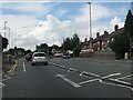
2
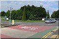
Roundabout
At the junction of Maidenwell Avenue, Hamilton Way, Lower Keyham Lane, and Hungarton Boulevard.
Image: © Mat Fascione
Taken: 17 Jun 2007
0.15 miles
3
Colchester Road (A563) north of Steins Lane
Image: © Peter Whatley
Taken: 28 Jul 2013
0.16 miles
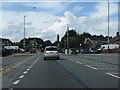
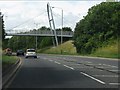
4
The A563 Hungarton Boulevard, Leicester
Image: © Mat Fascione
Taken: 17 Jun 2007
0.18 miles

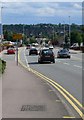
6
Colchester Road (A563) at Netherhall Road
Image: © Peter Whatley
Taken: 28 Jul 2013
0.21 miles
8
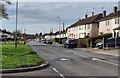
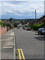
Netherhall Road in Leicester
Netherhall is a residential suburb, about three miles east of Leicester city centre.
Image: © Mat Fascione
Taken: 15 Feb 2024
0.24 miles