IMAGES TAKEN NEAR TO
Hayling Crescent, LEICESTER, LE5 0RH
Introduction
This page details the photographs taken nearby to Hayling Crescent, LE5 0RH by members of the Geograph project.
The Geograph project started in 2005 with the aim of publishing, organising and preserving representative images for every square kilometre of Great Britain, Ireland and the Isle of Man.

There are currently over 7.5m images from over14,400 individuals and you can help contribute to the project by visiting https://www.geograph.org.uk
Image Map
Images are licensed for reuse under creativecommons.org/licenses/by-sa/2.0
Notes
- Clicking on the map will re-center to the selected point.
- The higher the marker number, the further away the image location is from the centre of the postcode.
Image Listing (14 Images Found)
Images are licensed for reuse under creativecommons.org/licenses/by-sa/2.0
Image
Details
Distance
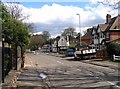
1
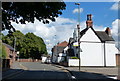
Tennis Court Drive, Humberstone, Leicester
This road leads down the hill from old Humberstone village to Uppingham Road and the city centre, which can just be seen in the distance.
Image: © Kate Jewell
Taken: 9 Nov 2005
0.08 miles
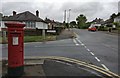
3
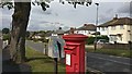
Greenland Drive in Humberstone, Leicester
The post box is on the corner of Tennis Court Drive.
Image: © Mat Fascione
Taken: 18 Sep 2017
0.12 miles
4
Tennis Court Drive in Humberstone
At the junction with Greenland Drive.
Image: © Mat Fascione
Taken: 26 Jul 2017
0.13 miles
5
Gipsy Lane towards Humberstone
Main Street is straight across, Humberstone Drive is to the right and Lower Keyham Lane is to the left.
Image: © Andrew Tatlow
Taken: 18 Apr 2013
0.13 miles
6
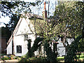
Thatched house, Humberstone, Leicester
This old thatched house is in the process of being rescued from dereliction. It is on the corner of Main Street and Tennis Court Drive.
Image: © Kate Jewell
Taken: 9 Nov 2005
0.14 miles
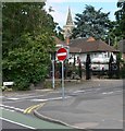
7
Main Street, Humberstone, Leicester
Old Humberstone Conservation area: remnants of the old village, now absorbed into the City of Leicester. This Conservation Area was designated in January 1974, and has an area of approximately 20.11 hectares. See Image for a view of the south side of the thatched house.
Image: © Kate Jewell
Taken: 9 Nov 2005
0.15 miles
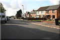
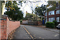
8
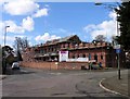
A DW Hicks Building Company project
21 properties for affordable rent on the corner of Gipsy Lane and Thurmaston Lane.
Image: © Andrew Tatlow
Taken: 18 Apr 2013
0.17 miles
9
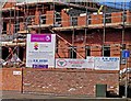
Signs at a DW Hicks Building Company project
Image: © Andrew Tatlow
Taken: 18 Apr 2013
0.17 miles