IMAGES TAKEN NEAR TO
Humberstone Road, LEICESTER, LE5 0EG
Introduction
This page details the photographs taken nearby to Humberstone Road, LE5 0EG by members of the Geograph project.
The Geograph project started in 2005 with the aim of publishing, organising and preserving representative images for every square kilometre of Great Britain, Ireland and the Isle of Man.

There are currently over 7.5m images from over14,400 individuals and you can help contribute to the project by visiting https://www.geograph.org.uk
Image Map
Images are licensed for reuse under creativecommons.org/licenses/by-sa/2.0
Notes
- Clicking on the map will re-center to the selected point.
- The higher the marker number, the further away the image location is from the centre of the postcode.
Image Listing (34 Images Found)
Images are licensed for reuse under creativecommons.org/licenses/by-sa/2.0
Image
Details
Distance
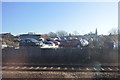
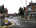
3
Uppingham Road, approaching Humberstone Road station, 1995
View westward on A47 Uppingham Road, Leicester. The bridge ahead carries the ex-Midland main lines northwards from Leicester (London Road, until 4/5/70), Humberstone Road station being just to the left of this bridge.
Image: © Ben Brooksbank
Taken: 29 May 1995
0.13 miles
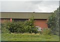
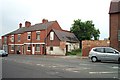
5
Humberstone Lodge
Humberstone Lodge and neighbouring houses prior to demolition in 2009.
Image: © Clive Cartwright
Taken: 24 Jan 2009
0.14 miles
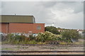
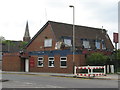
6
Forest Road Milk Depot
Photo showing the old stables, used by the local milkman. This small building has witnessed a few changes in its time. After its life as a stable, it was used as a Wood Yard. During the early 1980s it was purchased by the owners of the hotel next door, but fell into disuse by the 1990s. It was left derelict for many years until it was purchased in 2005.
Image: © Clive Cartwright
Taken: 1 Jun 2004
0.15 miles
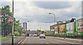
7
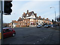
The end of Humberstone Road
The main A47 road from Leicester to Perterborough becomes Uppingham Road just here.
Image: © Andrew Tatlow
Taken: 13 Aug 2010
0.15 miles
8
Leicester (Spinney Hill) Charny
25 Spinney Hill Road. Modern locals pub.
Image: © the bitterman
Taken: 25 May 2010
0.15 miles
9
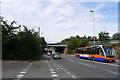
Humberstone Road entering Leicester
Passing beneath the Midland Mainline railway (Leicester and London St Pancras stations to the left)
Image: © Tim Heaton
Taken: 10 Jul 2019
0.16 miles
10
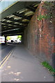
Railway Bridge 7SPC5 over Humberstone Road
There is an OS benchmark Image on the bridge wall near the right hand edge of the image
Image: © Roger Templeman
Taken: 5 May 2017
0.17 miles