IMAGES TAKEN NEAR TO
Verdale Avenue, LEICESTER, LE4 9TG
Introduction
This page details the photographs taken nearby to Verdale Avenue, LE4 9TG by members of the Geograph project.
The Geograph project started in 2005 with the aim of publishing, organising and preserving representative images for every square kilometre of Great Britain, Ireland and the Isle of Man.

There are currently over 7.5m images from over14,400 individuals and you can help contribute to the project by visiting https://www.geograph.org.uk
Image Map (Loading...)


Getting Data...Please wait
Leaflet Map data © OpenStreetMap
Images are licensed for reuse under creativecommons.org/licenses/by-sa/2.0
Notes
- Clicking on the map will re-center to the selected point.
- The higher the marker number, the further away the image location is from the centre of the postcode.
Image Listing (13 Images Found)
Images are licensed for reuse under creativecommons.org/licenses/by-sa/2.0
Image
Details
Distance
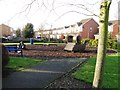
5
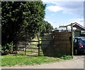
Back Entrance
From the satellite pictures it would appeaqr that this track goes along the bottom ends of the gardens of the houses on The Roundway; they are very long and narrow gardens.
Image: © Andrew Tatlow
Taken: 18 Apr 2013
0.20 miles
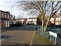
6
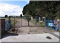
UCC Gates
This is the gateway to the former factory site of the Universal Conveyor Company Limited which may now be found at the Viaduct Works on Canon Street about a mile away.
Image: © Andrew Tatlow
Taken: 18 Apr 2013
0.20 miles
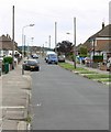
8
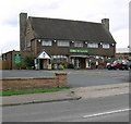
The Willow
Public House on Humberstone Lane in Thurmaston, Leicester.
Image: © Mat Fascione
Taken: 16 Jul 2007
0.22 miles
9
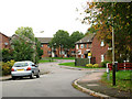
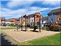
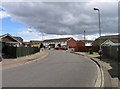
Warren Avenue, near Thurmaston, Leicester
Modern housing estate on the edge of the city.
Image: © Kate Jewell
Taken: 31 Oct 2005
0.22 miles