IMAGES TAKEN NEAR TO
Manston Close, LEICESTER, LE4 9NA
Introduction
This page details the photographs taken nearby to Manston Close, LE4 9NA by members of the Geograph project.
The Geograph project started in 2005 with the aim of publishing, organising and preserving representative images for every square kilometre of Great Britain, Ireland and the Isle of Man.

There are currently over 7.5m images from over14,400 individuals and you can help contribute to the project by visiting https://www.geograph.org.uk
Image Map
Images are licensed for reuse under creativecommons.org/licenses/by-sa/2.0
Notes
- Clicking on the map will re-center to the selected point.
- The higher the marker number, the further away the image location is from the centre of the postcode.
Image Listing (10 Images Found)
Images are licensed for reuse under creativecommons.org/licenses/by-sa/2.0
Image
Details
Distance
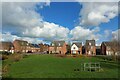
2
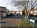
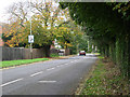
Warren Avenue, near Thurmaston, Leicester
Modern housing estate on the edge of the city.
Image: © Kate Jewell
Taken: 31 Oct 2005
0.07 miles
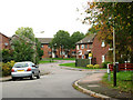
5
Barkby Thorpe Road, near Thurmaston, Leicester
Looking NE up Barkby Thorpe Road to the edge of the City. Barkby Thorpe is a small village about a mile up the road, with the larger Barkby just a little further on Image
Image: © Kate Jewell
Taken: 31 Oct 2005
0.18 miles
6
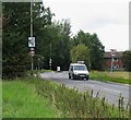
Width Restriction
There is a 7 feet width restriction to prevent any wider vehicles driving along Barkby Thorpe Road. Quite easy to get through if you hold your breath!
Image: © Andrew Tatlow
Taken: 8 Sep 2011
0.19 miles
7
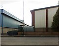
Industrial units, Mountain Road, Hamilton Business Park
Image: © Alex McGregor
Taken: 6 Oct 2012
0.20 miles
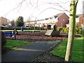
9
SuDS retention pond, Bowthorpe Close, Thurmaston
Image: © Tim Heaton
Taken: 24 Feb 2024
0.23 miles
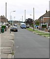
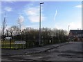
10
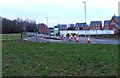
Width Restriction on Barkby Thorpe Road
New houses are being built up to the boundary of the Leicester Unitary Authority so the width restriction had been re-built almost on the boundary.
Image: © Andrew Tatlow
Taken: 12 Jan 2013
0.24 miles