IMAGES TAKEN NEAR TO
Ireton Road, LEICESTER, LE4 9ET
Introduction
This page details the photographs taken nearby to Ireton Road, LE4 9ET by members of the Geograph project.
The Geograph project started in 2005 with the aim of publishing, organising and preserving representative images for every square kilometre of Great Britain, Ireland and the Isle of Man.

There are currently over 7.5m images from over14,400 individuals and you can help contribute to the project by visiting https://www.geograph.org.uk
Image Map
Images are licensed for reuse under creativecommons.org/licenses/by-sa/2.0
Notes
- Clicking on the map will re-center to the selected point.
- The higher the marker number, the further away the image location is from the centre of the postcode.
Image Listing (11 Images Found)
Images are licensed for reuse under creativecommons.org/licenses/by-sa/2.0
Image
Details
Distance
3
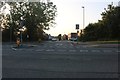
Victoria Road East at the junction of Fairfax Road
Image: © David Howard
Taken: 20 Sep 2020
0.09 miles
4
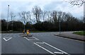
Fairfax Road at the junction of Victoria Road East
Humberstone Heights Golf Course is behind the trees.
Image: © David Howard
Taken: 5 Mar 2023
0.11 miles
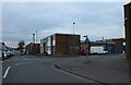
5
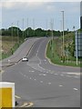
A6030
This is a brand new road constructed within the last couple of years.
Image: © Mat Fascione
Taken: 17 Jun 2007
0.11 miles
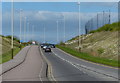
6
View down Victoria Road East in Humberstone
Image: © Mat Fascione
Taken: 18 Apr 2014
0.12 miles
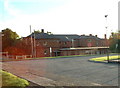
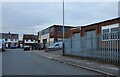
9
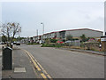
Lewisher Road, Troon Industrial area, Leicester
A vast industrial area takes up most of this square comprising Edwardian factories, mid-war workshops and modern industrial units as shown here.
Image: © Kate Jewell
Taken: 31 Oct 2005
0.20 miles
10
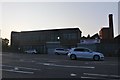
Select Windows on Victoria Road East, Humberstone
Image: © David Howard
Taken: 20 Sep 2020
0.21 miles