IMAGES TAKEN NEAR TO
Braybrooke Road, LEICESTER, LE4 9BQ
Introduction
This page details the photographs taken nearby to Braybrooke Road, LE4 9BQ by members of the Geograph project.
The Geograph project started in 2005 with the aim of publishing, organising and preserving representative images for every square kilometre of Great Britain, Ireland and the Isle of Man.

There are currently over 7.5m images from over14,400 individuals and you can help contribute to the project by visiting https://www.geograph.org.uk
Image Map
Images are licensed for reuse under creativecommons.org/licenses/by-sa/2.0
Notes
- Clicking on the map will re-center to the selected point.
- The higher the marker number, the further away the image location is from the centre of the postcode.
Image Listing (9 Images Found)
Images are licensed for reuse under creativecommons.org/licenses/by-sa/2.0
Image
Details
Distance
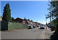
5
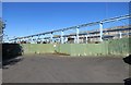
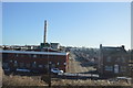
End of Rotherby Avenue
Beyond the fence is the site of Parker Plant who manufacture machines used in the mining and processing of sand and rocks. The gantries are part of a very long overhead crane.
Image: © Andrew Tatlow
Taken: 22 Jun 2018
0.21 miles
8
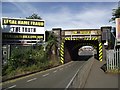
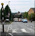
Bridge SPC5/17 carries the Midland main line across Gipsy Lane
Image: © Tim Glover
Taken: 23 Aug 2016
0.22 miles