IMAGES TAKEN NEAR TO
Oakland Avenue, LEICESTER, LE4 7SF
Introduction
This page details the photographs taken nearby to Oakland Avenue, LE4 7SF by members of the Geograph project.
The Geograph project started in 2005 with the aim of publishing, organising and preserving representative images for every square kilometre of Great Britain, Ireland and the Isle of Man.

There are currently over 7.5m images from over14,400 individuals and you can help contribute to the project by visiting https://www.geograph.org.uk
Image Map
Images are licensed for reuse under creativecommons.org/licenses/by-sa/2.0
Notes
- Clicking on the map will re-center to the selected point.
- The higher the marker number, the further away the image location is from the centre of the postcode.
Image Listing (44 Images Found)
Images are licensed for reuse under creativecommons.org/licenses/by-sa/2.0
Image
Details
Distance
1
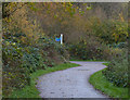
Cycleway and path at Watermead Country Park
Image: © Mat Fascione
Taken: 23 Nov 2013
0.12 miles
2
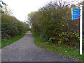
Cycleway and path at Watermead Country Park
Image: © Mat Fascione
Taken: 23 Nov 2013
0.13 miles
3
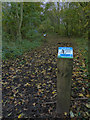
Climate Trail at Watermead Country Park
The climate trail was installed at the park in August 2011.
Image: © Mat Fascione
Taken: 23 Nov 2013
0.15 miles
5
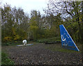
Climate Trail at Watermead Country Park
The climate trail was installed at the park in August 2011.
On the left is a three-quarters size polar bear, and on the right is a climbing wall in the style of an airplane tail fin. In the trees, behind the polar bear, is a rope and timber bridge.
Image: © Mat Fascione
Taken: 23 Nov 2013
0.16 miles
7
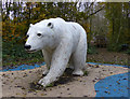
Polar bear
Part of a Climate Trail at Watermead Country Park, it was installed at the park in August 2011.
Image: © Mat Fascione
Taken: 23 Nov 2013
0.17 miles
8
Polar bear at the Watermead Country Park
Part of a Climate Trail at the Watermead Country Park, it was installed at the park in August 2011.
Image: © Mat Fascione
Taken: 23 Nov 2017
0.17 miles
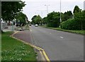
9
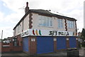
BJ'S PIZZA, #429Melton Road at Hardy's Avenue junction
Image: © Roger Templeman
Taken: 9 May 2018
0.18 miles
10
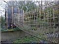
Rope and timber bridge
Crossing a concrete waterway at the Watermead Country Park, it is part of a climate trail which was installed at the park in August 2011.
Image: © Mat Fascione
Taken: 23 Nov 2013
0.19 miles