IMAGES TAKEN NEAR TO
Woodbridge Road, LEICESTER, LE4 7RG
Introduction
This page details the photographs taken nearby to Woodbridge Road, LE4 7RG by members of the Geograph project.
The Geograph project started in 2005 with the aim of publishing, organising and preserving representative images for every square kilometre of Great Britain, Ireland and the Isle of Man.

There are currently over 7.5m images from over14,400 individuals and you can help contribute to the project by visiting https://www.geograph.org.uk
Image Map
Images are licensed for reuse under creativecommons.org/licenses/by-sa/2.0
Notes
- Clicking on the map will re-center to the selected point.
- The higher the marker number, the further away the image location is from the centre of the postcode.
Image Listing (89 Images Found)
Images are licensed for reuse under creativecommons.org/licenses/by-sa/2.0
Image
Details
Distance
1
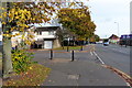
Checketts Road in Belgrave
At the junction with Bellholme Close.
Image: © Mat Fascione
Taken: 25 Oct 2015
0.13 miles
3
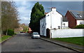
Gladstone Cottage on Bath Street, Belgrave
Image: © Mat Fascione
Taken: 7 Feb 2016
0.16 miles
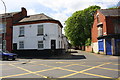
4
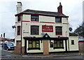
The Bull's Head
This pub (now closed) is on the corner of Bath Street and Loughborough Road.
Image: © Mat Fascione
Taken: 21 Feb 2017
0.17 miles
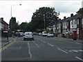
5
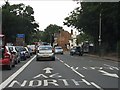
A6 North
Road marking on Loughborough Road, a short way north of Checketts Road.
Image: © Peter Whatley
Taken: 28 Jul 2013
0.17 miles
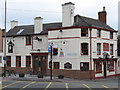
7
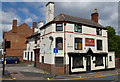
The Bull's Head
Former public house on the corner of Loughborough Road and Bath Street, in the Belgrave area of Leicester. It has been converted into apartments.
Image: © Mat Fascione
Taken: 2 May 2020
0.18 miles
8
Belgrave Hall, Belgrave Village, Leicester
A view from the Holdsworth Memorial, i.e. a pedestal and stone urn, towards the garden at the rear of “The Hall”. Gates hung from these pillars secured the main entrance/exit to the premises from Prattle Hill (now Loughborough Road), i.e. this photograph was taken from what was part of the public highway until the C19th.
Image: © David Hallam-Jones
Taken: 16 Aug 2017
0.18 miles
9
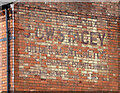
Ghost sign, Loughborough Road, Leicester
It reads: "Phone Birstall 117 / J.C.W. Stacey / Builder & Contractor / Repairs in All Branches. Estimates Submitted / Residence Riverhome Loughborough Rd Birstall".
Image: © Stephen Richards
Taken: 24 Jun 2015
0.18 miles
10
#280 Loughborough Road at Vicarage Lane junction
Image: © Roger Templeman
Taken: 9 May 2018
0.18 miles