IMAGES TAKEN NEAR TO
Clarke Street, LEICESTER, LE4 7NB
Introduction
This page details the photographs taken nearby to Clarke Street, LE4 7NB by members of the Geograph project.
The Geograph project started in 2005 with the aim of publishing, organising and preserving representative images for every square kilometre of Great Britain, Ireland and the Isle of Man.

There are currently over 7.5m images from over14,400 individuals and you can help contribute to the project by visiting https://www.geograph.org.uk
Image Map (Loading...)


Getting Data...Please wait
Leaflet Map data © OpenStreetMap
Images are licensed for reuse under creativecommons.org/licenses/by-sa/2.0
Notes
- Clicking on the map will re-center to the selected point.
- The higher the marker number, the further away the image location is from the centre of the postcode.
Image Listing (28 Images Found)
Images are licensed for reuse under creativecommons.org/licenses/by-sa/2.0
Image
Details
Distance
1
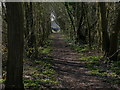
Wooded path leading to Lanesborough Road
Image: © Mat Fascione
Taken: 13 Mar 2016
0.12 miles
2
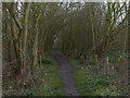
Path and woodland near Lanesborough Road
Image: © Mat Fascione
Taken: 7 Feb 2016
0.13 miles
3
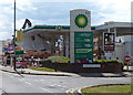
Closed petrol station along Melton Road
This petrol station has been closed after being damaged in a fire, it was next door to the Premier Works building.
The Premier Works building was at the corner of Woodbridge Road and Melton Road. A large fire occurred on the morning of August 7th 2014, completely destroying the building. This was two days after the fire and the building was being demolished.
Image: © Mat Fascione
Taken: 9 Aug 2014
0.13 miles
4
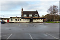
Owl & Pussycat public house
Along Melton Road in Leicester.
Image: © Mat Fascione
Taken: 7 Dec 2013
0.13 miles
5
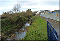
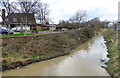
Path along Melton Brook
The brook is flowing northwest towards the River Soar, about 500 metres away.
Image: © Mat Fascione
Taken: 7 Dec 2013
0.13 miles
6
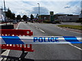
Closure of Melton Road
The closure was due to a massive fire at the Premier Works building at the corner with Woodbridge Road. The fire happened on the morning of August 7th 2014, this was two days after the fire and the building was being demolished.
Image: © Mat Fascione
Taken: 9 Aug 2014
0.14 miles
7
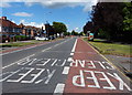
Melton Road in Rushey Mead
The road has been closed due to the demolition of a factory after a fire.
Image: © Mat Fascione
Taken: 9 Aug 2014
0.14 miles
8
The Owl and the Pussycat went to sea
Public house on the outskirts of Leicester.
Image: © Steve Fareham
Taken: 15 Nov 2007
0.14 miles
9
Melton Brook in Rushey Mead
On the left is the Owl & Pussycat public house.
Image: © Mat Fascione
Taken: 7 Feb 2016
0.14 miles
10
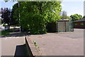
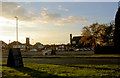
Melton Road at entrance to police station
There were public conveniences here in the 1960s
Image: © Roger Templeman
Taken: 5 May 2017
0.14 miles