IMAGES TAKEN NEAR TO
Wyvern Avenue, LEICESTER, LE4 7HH
Introduction
This page details the photographs taken nearby to Wyvern Avenue, LE4 7HH by members of the Geograph project.
The Geograph project started in 2005 with the aim of publishing, organising and preserving representative images for every square kilometre of Great Britain, Ireland and the Isle of Man.

There are currently over 7.5m images from over14,400 individuals and you can help contribute to the project by visiting https://www.geograph.org.uk
Image Map
Images are licensed for reuse under creativecommons.org/licenses/by-sa/2.0
Notes
- Clicking on the map will re-center to the selected point.
- The higher the marker number, the further away the image location is from the centre of the postcode.
Image Listing (16 Images Found)
Images are licensed for reuse under creativecommons.org/licenses/by-sa/2.0
Image
Details
Distance
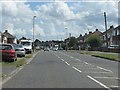
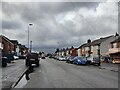
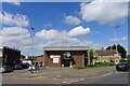
2
South end of Strathmore Avenue, Rushey Fields
Seen from Wyvern Avenue.
Image: © Richard Vince
Taken: 11 Mar 2017
0.13 miles
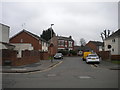
3
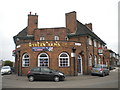
The Wyvern Arms, Rushey Fields
Situated in the V of Kerrysdale Avenue (left) and Barkby Road, hence its interesting shape.
Image: © Richard Vince
Taken: 11 Mar 2017
0.16 miles
5
Church of All Saints, Belgrave, Leicester
Originally the church of St Gabriel (the angel above the door)
http://liberalengland.blogspot.com/2011/04/st-gabriels-kerrysdale-avenue-leicester.html
Image: © Tim Heaton
Taken: 10 May 2022
0.17 miles
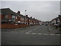
6
North end of Oliver Road, Rushey Fields
Seen from Barkby Road.
Image: © Richard Vince
Taken: 11 Mar 2017
0.18 miles
7
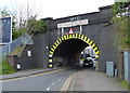
Railway bridge across Barkby Road, Leicester
Image: © Mat Fascione
Taken: 18 Apr 2014
0.21 miles
8
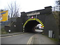
Railway bridge over Barkby Road, Rushey Fields
One of several low bridges carrying the Midland Main Line across roads in Leicester's northern suburbs. First Leicester is sufficiently brave to operate service 21 under this one, inevitably using single deckers.
Image: © Richard Vince
Taken: 11 Mar 2017
0.21 miles
9
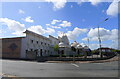
BAPS Shri Swaminarayan Mandir
"A white limestone Hindu temple. The mandir building is a former denim factory and it has now become one of the largest and most stunning mandirs in the Midlands." https://www.storyofleicester.info/faith-belief/baps-shri-swaminarayan-mandir/
Image: © Tim Heaton
Taken: 10 May 2022
0.22 miles
10
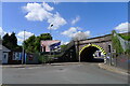
Barkby Road passing beneath the Midland Main Line, Leicester
Image: © Tim Heaton
Taken: 10 May 2022
0.22 miles