IMAGES TAKEN NEAR TO
Gleneagles Avenue, LEICESTER, LE4 7GB
Introduction
This page details the photographs taken nearby to Gleneagles Avenue, LE4 7GB by members of the Geograph project.
The Geograph project started in 2005 with the aim of publishing, organising and preserving representative images for every square kilometre of Great Britain, Ireland and the Isle of Man.

There are currently over 7.5m images from over14,400 individuals and you can help contribute to the project by visiting https://www.geograph.org.uk
Image Map (Loading...)


Getting Data...Please wait
Leaflet Map data © OpenStreetMap
Images are licensed for reuse under creativecommons.org/licenses/by-sa/2.0
Notes
- Clicking on the map will re-center to the selected point.
- The higher the marker number, the further away the image location is from the centre of the postcode.
Image Listing (9 Images Found)
Images are licensed for reuse under creativecommons.org/licenses/by-sa/2.0
Image
Details
Distance
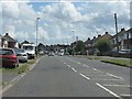
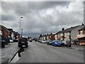
2
South end of Strathmore Avenue, Rushey Fields
Seen from Wyvern Avenue.
Image: © Richard Vince
Taken: 11 Mar 2017
0.18 miles
3
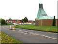
Gleneagles Avenue, Rushey Mead, Leicester
Catholic Church of Our Lady by Soar Valley College with a dramatic copper roof.
Image: © Kate Jewell
Taken: 31 Oct 2005
0.20 miles
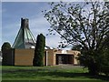
5
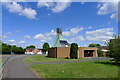
Catholic Church of Our Lady, Rushey Mead, Leicester
Built 1975. For description, https://taking-stock.org.uk/building/leicester-our-lady-of-good-counsel/
Image: © Tim Heaton
Taken: 10 May 2022
0.22 miles
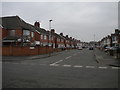
7
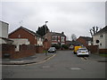
North end of Oliver Road, Rushey Fields
Seen from Barkby Road.
Image: © Richard Vince
Taken: 11 Mar 2017
0.24 miles
8
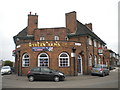
The Wyvern Arms, Rushey Fields
Situated in the V of Kerrysdale Avenue (left) and Barkby Road, hence its interesting shape.
Image: © Richard Vince
Taken: 11 Mar 2017
0.25 miles
9
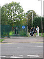
Gleneagles Walk, Rushey Mead, Leicester
Walkway and cycle track from Soar Valley College on Gleneagles Avenue to Rushey Mead Secondary School on Melton Road.
Image: © Kate Jewell
Taken: 31 Oct 2005
0.25 miles