IMAGES TAKEN NEAR TO
Yorkshire Road, LEICESTER, LE4 6PJ
Introduction
This page details the photographs taken nearby to Yorkshire Road, LE4 6PJ by members of the Geograph project.
The Geograph project started in 2005 with the aim of publishing, organising and preserving representative images for every square kilometre of Great Britain, Ireland and the Isle of Man.

There are currently over 7.5m images from over14,400 individuals and you can help contribute to the project by visiting https://www.geograph.org.uk
Image Map (Loading...)


Getting Data...Please wait
Leaflet Map data © OpenStreetMap
Images are licensed for reuse under creativecommons.org/licenses/by-sa/2.0
Notes
- Clicking on the map will re-center to the selected point.
- The higher the marker number, the further away the image location is from the centre of the postcode.
Image Listing (21 Images Found)
Images are licensed for reuse under creativecommons.org/licenses/by-sa/2.0
Image
Details
Distance
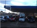
8
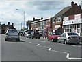
Apna Punjab Meat Shop at Canon Street / Yorkshire Road junction
Image: © Roger Templeman
Taken: 5 May 2017
0.18 miles
9
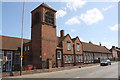
Rushey Mead Primary School, Gipsy Lane
There is an OS benchmark Image above steps beside the tower
Image: © Roger Templeman
Taken: 5 May 2017
0.18 miles
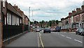
10
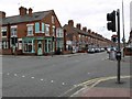
Marfitt Street, Harrison Road junction
Image: © Mat Fascione
Taken: 17 Jun 2007
0.18 miles