IMAGES TAKEN NEAR TO
Harrogate Road, LEICESTER, LE4 6GS
Introduction
This page details the photographs taken nearby to Harrogate Road, LE4 6GS by members of the Geograph project.
The Geograph project started in 2005 with the aim of publishing, organising and preserving representative images for every square kilometre of Great Britain, Ireland and the Isle of Man.

There are currently over 7.5m images from over14,400 individuals and you can help contribute to the project by visiting https://www.geograph.org.uk
Image Map
Images are licensed for reuse under creativecommons.org/licenses/by-sa/2.0
Notes
- Clicking on the map will re-center to the selected point.
- The higher the marker number, the further away the image location is from the centre of the postcode.
Image Listing (27 Images Found)
Images are licensed for reuse under creativecommons.org/licenses/by-sa/2.0
Image
Details
Distance
1
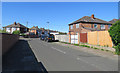
Junction at the end of Carter Street
Straight across is Dean Road, Harrogate Road is to the left and Gayton Avenue is to the right.
Image: © Andrew Tatlow
Taken: 22 Jun 2018
0.03 miles
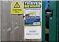
2
Sign at electricity substation 33D3092 CARTER STREET
Image: © Andrew Tatlow
Taken: 22 Jun 2018
0.03 miles
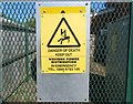
3
Notices at electricity substation 33D3092 CARTER STREET
Image: © Andrew Tatlow
Taken: 22 Jun 2018
0.03 miles
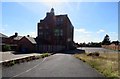
5

Bell tower at former Hugh Latimer School
One guesses that this building is the former Hugh Latimer school which was on Belper Street; it is listed at http://www.british-history.ac.uk/vch/leics/vol4/pp335-337 and is on the 1890ish OS maps. It was a Boys' Secondary Modern School in 1955. It is now the home of Little Champs Nursery.
Image: © Andrew Tatlow
Taken: 22 Jun 2018
0.04 miles
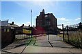
6
Former Hugh Latimer School now occupied by Little Champs Nursery
One guesses that this building is the former Hugh Latimer school which was on Belper Street; it is listed at http://www.british-history.ac.uk/vch/leics/vol4/pp335-337 and is on the 1890ish OS maps. It was a Boys' Secondary Modern School in 1955.
Image: © Andrew Tatlow
Taken: 22 Jun 2018
0.04 miles
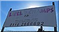
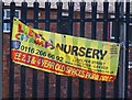
7
Vehicle entrance for Little Champs Nursery
See Image
Image: © Andrew Tatlow
Taken: 22 Jun 2018
0.04 miles
8
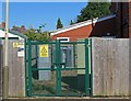
Electricity substation 33D3092 CARTER STREET
The OS Grid Line cuts across the compound from the front right corner to the back left corner!
Image
Image
Image: © Andrew Tatlow
Taken: 22 Jun 2018
0.04 miles