IMAGES TAKEN NEAR TO
Harrington Street, LEICESTER, LE4 6ET
Introduction
This page details the photographs taken nearby to Harrington Street, LE4 6ET by members of the Geograph project.
The Geograph project started in 2005 with the aim of publishing, organising and preserving representative images for every square kilometre of Great Britain, Ireland and the Isle of Man.

There are currently over 7.5m images from over14,400 individuals and you can help contribute to the project by visiting https://www.geograph.org.uk
Image Map
Images are licensed for reuse under creativecommons.org/licenses/by-sa/2.0
Notes
- Clicking on the map will re-center to the selected point.
- The higher the marker number, the further away the image location is from the centre of the postcode.
Image Listing (35 Images Found)
Images are licensed for reuse under creativecommons.org/licenses/by-sa/2.0
Image
Details
Distance
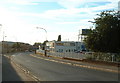
2
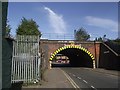
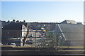
Bridge SPC5/10 carries the Midland main line over Hammercliffe Road
Image: © Tim Glover
Taken: 24 Aug 2016
0.07 miles
3
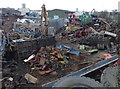
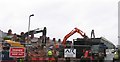
Scrap yard along Ulverscroft Road, Leicester
Image: © Mat Fascione
Taken: 25 Mar 2018
0.08 miles
5
Frisby Road 2012
The typical backstreet factory is no more following a fire on 21 April 2012. Compare with Image
Image: © Andrew Tatlow
Taken: 25 Apr 2012
0.16 miles
6
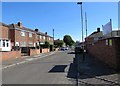
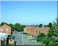
Carter Street southwards
Image: © Andrew Tatlow
Taken: 22 Jun 2018
0.17 miles
8
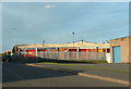
Ulverscroft Road
Industrial area West of Railway
Image: © Chris Shaw
Taken: Unknown
0.19 miles