IMAGES TAKEN NEAR TO
Beaumanor Road, LEICESTER, LE4 5QA
Introduction
This page details the photographs taken nearby to Beaumanor Road, LE4 5QA by members of the Geograph project.
The Geograph project started in 2005 with the aim of publishing, organising and preserving representative images for every square kilometre of Great Britain, Ireland and the Isle of Man.

There are currently over 7.5m images from over14,400 individuals and you can help contribute to the project by visiting https://www.geograph.org.uk
Image Map (Loading...)


Getting Data...Please wait
Leaflet Map data © OpenStreetMap
Images are licensed for reuse under creativecommons.org/licenses/by-sa/2.0
Notes
- Clicking on the map will re-center to the selected point.
- The higher the marker number, the further away the image location is from the centre of the postcode.
Image Listing (127 Images Found)
Images are licensed for reuse under creativecommons.org/licenses/by-sa/2.0
Image
Details
Distance
1
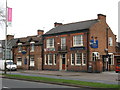
Leicester Broadway
265-265 Abbey Lane. Former Hardys & Hansons brewery pub
Image: © the bitterman
Taken: 6 Apr 2010
0.02 miles
2
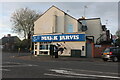
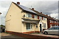
Mark Jarvis betting office on Corporation Road, Leicester
Image: © David Howard
Taken: 28 Apr 2024
0.07 miles
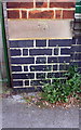
3
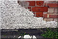
Benchmark on Wade Street face of #311 Abbey Lane
Partly hidden by pebbledash, the Ordnance Survey cut mark benchmark is described on the Bench Mark Database at https://www.bench-marks.org.uk/bm102287
Image: © Roger Templeman
Taken: 9 May 2018
0.10 miles
4
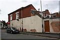
Wade Street face of AUM Supermarket, #311-315 Abbey Lane
The pebbledash is breaking away, exposing an OS benchmark Image behind the missing patch in the middle of the image
Image: © Roger Templeman
Taken: 9 May 2018
0.10 miles
5
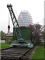
Crane and Space Centre
The National Space Centre seen from the, next door, Abbey Pumping Station.
Image: © Dave Pickersgill
Taken: 30 Oct 2004
0.13 miles
6
Houses on Beaumont Leys Lane
There is an OS benchmark Image on the side of the nearest house (#35) near its front corner
Image: © Roger Templeman
Taken: 9 May 2018
0.15 miles
7
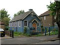
Community Of Christ, Church, Leicester
An unusual small, blue church at 330 Abbey Lane.http://www.cofchrist.org.uk/leicester/
Image: © David P Howard
Taken: 14 Sep 2010
0.16 miles
8
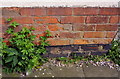
Benchmark on #35 Beaumont Leys Lane
Ordnance Survey cut mark benchmark described on the Bench Mark Database at https://www.bench-marks.org.uk/bm102373
Image: © Roger Templeman
Taken: 9 May 2018
0.16 miles
9
Benchmark on wall pier at Abbey Pumping Station Museum
Ordnance Survey cut mark benchmark described on the Bench Mark Database at https://www.bench-marks.org.uk/bm102374
Image: © Roger Templeman
Taken: 9 May 2018
0.16 miles
10
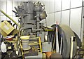
Ruston and Hornsby Diesel Engine
Possibly an old pumping engine, seen the in Abbey pumping stores building. Also a couple of smaller diesels, possibly from mills (email for pictures).
Image: © Ashley Dace
Taken: 4 Dec 2011
0.17 miles