IMAGES TAKEN NEAR TO
Loughborough Road, LEICESTER, LE4 5PN
Introduction
This page details the photographs taken nearby to Loughborough Road, LE4 5PN by members of the Geograph project.
The Geograph project started in 2005 with the aim of publishing, organising and preserving representative images for every square kilometre of Great Britain, Ireland and the Isle of Man.

There are currently over 7.5m images from over14,400 individuals and you can help contribute to the project by visiting https://www.geograph.org.uk
Image Map (Loading...)


Getting Data...Please wait
Leaflet Map data © OpenStreetMap
Images are licensed for reuse under creativecommons.org/licenses/by-sa/2.0
Notes
- Clicking on the map will re-center to the selected point.
- The higher the marker number, the further away the image location is from the centre of the postcode.
Image Listing (185 Images Found)
Images are licensed for reuse under creativecommons.org/licenses/by-sa/2.0
Image
Details
Distance
2
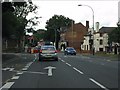
Loughborough Road, Belgrave, Leicester
The A6 looking NW towards Red Hill roundabout from the Thurcaston Road junction. The building on the left is a converted school, now an architects' office.
(Note 2007: Architect has moved and the building is looking for a new owner.)
Image: © Kate Jewell
Taken: 25 Oct 2005
0.03 miles
3
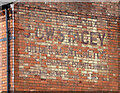
Ghost sign, Loughborough Road, Leicester
It reads: "Phone Birstall 117 / J.C.W. Stacey / Builder & Contractor / Repairs in All Branches. Estimates Submitted / Residence Riverhome Loughborough Rd Birstall".
Image: © Stephen Richards
Taken: 24 Jun 2015
0.06 miles
4
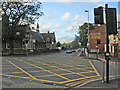
Loughborough Road at Thurcaston Road
The painted arrow for the left turn is an interesting example of the road marker's art.
Image: © Peter Whatley
Taken: 28 Jul 2013
0.07 miles
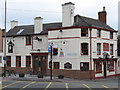
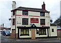
6
The Bull's Head
Former public house on the corner of Loughborough Road and Bath Street, in the Belgrave area of Leicester. It has been converted into apartments.
Image: © Mat Fascione
Taken: 2 May 2020
0.07 miles
7
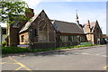
#346 Loughborough Road, former school converted to offices
There is an OS benchmark Image on the near corner of the jut (right of the road name sign)
Image: © Roger Templeman
Taken: 9 May 2018
0.08 miles
8
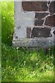
Benchmark on converted school, #346 Loughborough Road
Ordnance Survey cut mark benchmark described on the Bench Mark Database at https://www.bench-marks.org.uk/bm102289
Image: © Roger Templeman
Taken: 9 May 2018
0.08 miles
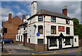
9
The Bull's Head
This pub (now closed) is on the corner of Bath Street and Loughborough Road.
Image: © Mat Fascione
Taken: 21 Feb 2017
0.08 miles
10
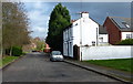
Gladstone Cottage on Bath Street, Belgrave
Image: © Mat Fascione
Taken: 7 Feb 2016
0.09 miles