IMAGES TAKEN NEAR TO
Exploration Drive, LEICESTER, LE4 5NU
Introduction
This page details the photographs taken nearby to Exploration Drive, LE4 5NU by members of the Geograph project.
The Geograph project started in 2005 with the aim of publishing, organising and preserving representative images for every square kilometre of Great Britain, Ireland and the Isle of Man.

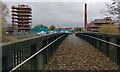
There are currently over 7.5m images from over14,400 individuals and you can help contribute to the project by visiting https://www.geograph.org.uk
Image Map
Images are licensed for reuse under creativecommons.org/licenses/by-sa/2.0
Notes
- Clicking on the map will re-center to the selected point.
- The higher the marker number, the further away the image location is from the centre of the postcode.
Image Listing (246 Images Found)
Images are licensed for reuse under creativecommons.org/licenses/by-sa/2.0
Image
Details
Distance
1
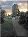
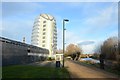
National Space Centre, Leicester.
A show piece science centre with a real space rocket. The building looks like an inflated balloon! More info at http://www.nssc.co.uk/ and http://www.bbc.co.uk/leicester/virtual_tours/space_centre/index.shtml
Image: © Kate Jewell
Taken: 25 Oct 2005
0.03 miles
2
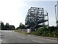
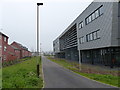
Construction site on Exploration Drive, Leicester
This area specialises in technology industries, being close to the National Space Centre.
Image: © Ruth Sharville
Taken: 6 Sep 2023
0.03 miles
3
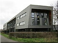
Dock, Leicester
Technology innovation centre.
Image: © Jonathan Thacker
Taken: 2 Mar 2023
0.04 miles
4
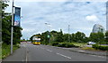
Exploration Drive at Pioneer Park
On the right is the National Space Centre in Leicester.
Image: © Mat Fascione
Taken: 27 May 2017
0.05 miles
5
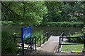
Footbridge crossing the River Soar
The bridge links the National Space Centre with the derelict Abbey Meadows, which was the site of the former Wolsey Factory, the water tower and two chimneys are all that remain. A new housing estate is being built on the site, the water tower and Wolsey chimney will be retained and restored.
Image, same view taken six months earlier.
Image: © Mat Fascione
Taken: 21 Nov 2017
0.05 miles
6
New science park at the Abbey Meadows
The houses on the left are on Beagle Close.
Image: © Mat Fascione
Taken: 3 Apr 2014
0.05 miles
7
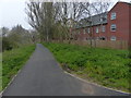
Riverside Way at the Abbey Meadows
The River Soar is to the left of the path, the new houses are on Beagle Close.
Image: © Mat Fascione
Taken: 3 Apr 2014
0.06 miles
9
Leicester Space Station
R.Soar to the right. Image]
Image: © Ashley Dace
Taken: 27 Jan 2012
0.08 miles
10
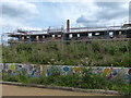
Constructing houses at the Abbey Meadows
The Abbey Meadows was the site of the former Wolsey Factory, a water tower and chimney are all that remain.
Image, same view taken 6½ months earlier.
Image, same view taken 3 months later.
Image: © Mat Fascione
Taken: 20 Aug 2017
0.09 miles