IMAGES TAKEN NEAR TO
Loughborough Road, LEICESTER, LE4 5LR
Introduction
This page details the photographs taken nearby to Loughborough Road, LE4 5LR by members of the Geograph project.
The Geograph project started in 2005 with the aim of publishing, organising and preserving representative images for every square kilometre of Great Britain, Ireland and the Isle of Man.

There are currently over 7.5m images from over14,400 individuals and you can help contribute to the project by visiting https://www.geograph.org.uk
Image Map
Images are licensed for reuse under creativecommons.org/licenses/by-sa/2.0
Notes
- Clicking on the map will re-center to the selected point.
- The higher the marker number, the further away the image location is from the centre of the postcode.
Image Listing (155 Images Found)
Images are licensed for reuse under creativecommons.org/licenses/by-sa/2.0
Image
Details
Distance
1
Checketts Road in Belgrave
At the junction with Bellholme Close.
Image: © Mat Fascione
Taken: 25 Oct 2015
0.06 miles
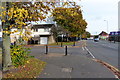
2
#280 Loughborough Road at Vicarage Lane junction
Image: © Roger Templeman
Taken: 9 May 2018
0.07 miles
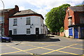
3
Vicarage Lane in Belgrave, Leicester
On the left is the wall surrounding St Peter's churchyard.
Image: © Mat Fascione
Taken: 30 Mar 2014
0.08 miles
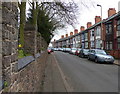
4
Vicarage Lane, Belgrave, Leicester
An attractive row of terraced cottages opposite the church.
Image: © Kate Jewell
Taken: 25 Oct 2005
0.09 miles
5
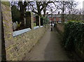
Path down the side of St Peter's Church
This path runs between Vicarage Lane and Church Road in Belgrave.
Image: © Mat Fascione
Taken: 30 Mar 2014
0.12 miles
6
Footpath to Vicarage Lane, Belgrave
Image: © Jonathan Thacker
Taken: 2 Mar 2023
0.12 miles
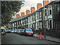
7
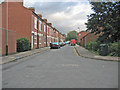
Shirley Street, Belgrave, Leicester
"On the street" terraced houses.
Image: © Kate Jewell
Taken: 25 Oct 2005
0.12 miles
8

St Peter's Church, Belgrave Village, Leicester
Belgrave House, Belgrave Hall and St Peter's Church, plus a couple of (now converted) ancillary buildings, occupy most of a short, privately(?) maintained, road, i.e. Church Road, in a hamlet-like setting. Loughborough Road is a 2-3 minute walk away on the other side of the church and Vicarage Lane, a more modern road of terraced and detached houses, lies to the photographer's left. The main part of the present church dates from the C13th century, although some features from the former C12th church have been preserved, including the south doorway (just visible on the left-hand margin of this photo) and the two lower stages of the tower. A north porch was added in 1912. Belgrave is regarded by some as the cradle of the Roman Catholic revival in Leicester. From at least the last quarter of the C17th until the early years of the C18th, the Byerley family of Belgrave Hall had a Franciscan chaplain, and the Franciscans were probably succeeded by Jesuits. There were said to be five Roman Catholics at Belgrave in 1676 and 18 Catholic families out of a total of 60 in 1709. The Dominican mission to Leicester was revived at Belgrave in 1746 and moved into the town in 1777. The church is Grade II* listed, redundant and apparently "For Sale".
Image: © David Hallam-Jones
Taken: 16 Aug 2017
0.12 miles
9
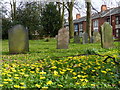
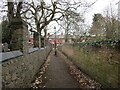
Gravestones at St Peter's Church
The houses are along Vicarage Lane in Belgrave.
Image: © Mat Fascione
Taken: 30 Mar 2014
0.12 miles
10
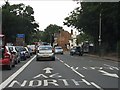
A6 North
Road marking on Loughborough Road, a short way north of Checketts Road.
Image: © Peter Whatley
Taken: 28 Jul 2013
0.12 miles