IMAGES TAKEN NEAR TO
Elmdale Street, LEICESTER, LE4 5JB
Introduction
This page details the photographs taken nearby to Elmdale Street, LE4 5JB by members of the Geograph project.
The Geograph project started in 2005 with the aim of publishing, organising and preserving representative images for every square kilometre of Great Britain, Ireland and the Isle of Man.

There are currently over 7.5m images from over14,400 individuals and you can help contribute to the project by visiting https://www.geograph.org.uk
Image Map
Images are licensed for reuse under creativecommons.org/licenses/by-sa/2.0
Notes
- Clicking on the map will re-center to the selected point.
- The higher the marker number, the further away the image location is from the centre of the postcode.
Image Listing (165 Images Found)
Images are licensed for reuse under creativecommons.org/licenses/by-sa/2.0
Image
Details
Distance
3
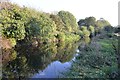
Grand Union Canal/ River Soar
A view of the canal in the late evening.
Image: © Ashley Dace
Taken: Unknown
0.07 miles
4
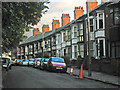
Vicarage Lane, Belgrave, Leicester
An attractive row of terraced cottages opposite the church.
Image: © Kate Jewell
Taken: 25 Oct 2005
0.07 miles
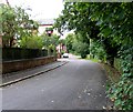
6
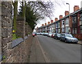
Vicarage Lane in Belgrave, Leicester
On the left is the wall surrounding St Peter's churchyard.
Image: © Mat Fascione
Taken: 30 Mar 2014
0.08 miles
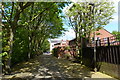
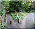
7
Path down the side of St Peter's Church
This path runs between Vicarage Lane and Church Road in Belgrave.
Image: © Mat Fascione
Taken: 30 Mar 2014
0.08 miles
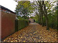
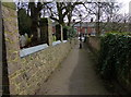
8
Footpath to Vicarage Lane, Belgrave
Image: © Jonathan Thacker
Taken: 2 Mar 2023
0.08 miles
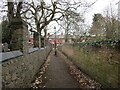
10
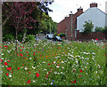
Wildflowers at Vicarage Lane in Belgrave
Image: © Mat Fascione
Taken: 14 Jun 2015
0.08 miles