IMAGES TAKEN NEAR TO
Abbey Meadows, LEICESTER, LE4 5FQ
Introduction
This page details the photographs taken nearby to Abbey Meadows, LE4 5FQ by members of the Geograph project.
The Geograph project started in 2005 with the aim of publishing, organising and preserving representative images for every square kilometre of Great Britain, Ireland and the Isle of Man.

There are currently over 7.5m images from over14,400 individuals and you can help contribute to the project by visiting https://www.geograph.org.uk
Image Map
Images are licensed for reuse under creativecommons.org/licenses/by-sa/2.0
Notes
- Clicking on the map will re-center to the selected point.
- The higher the marker number, the further away the image location is from the centre of the postcode.
Image Listing (323 Images Found)
Images are licensed for reuse under creativecommons.org/licenses/by-sa/2.0
Image
Details
Distance
1
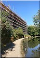
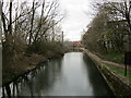
Apartment block under construction at Wolsey Island
The apartments are on Wolsey/Sock Island or Abbey Meadows, the site of the former Wolsey Factory. It is next to the towpath of the Grand Union Canal.
Image, the same view taken 6 years later.
Image: © Mat Fascione
Taken: 15 Jul 2018
0.00 miles
2
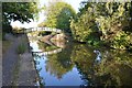
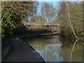
Grand Union Canal/ River Soar
A bridge takes the towpath onto the other side of the canal near Belgrave Lock.
Image: © Ashley Dace
Taken: Unknown
0.01 miles
3
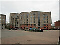
Apartment block, Abbey Meadows, Leicester
Image: © Jonathan Thacker
Taken: 2 Mar 2023
0.01 miles
4
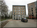
Apartment block, Abbey Meadows, Leicester
Image: © Jonathan Thacker
Taken: 2 Mar 2023
0.02 miles
5
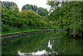
Grand Union Canal/Soar Navigation in Leicester
This is a late 19th century canalised section of the Grand Union Canal/Soar Navigation south-west of and approaching Belgrave Lock, No 44 and a confluence with the original river course. The canal here is level with the nearby River Soar (off to the left past Frog Island) so is prone to slight flooding when the river is high. Drainage is over the weir by Belgrave Lock.
The derelict industrial buildings ahead have since been demolished.
N. Chadwick has noted:
Image: © Roger Kidd
Taken: 25 Aug 2013
0.02 miles
6
New houses next to the Grand Union Canal
The houses are on Wolsey Island or Abbey Meadows, the site of the former Wolsey Factory.
Image: © Mat Fascione
Taken: 1 Jan 2018
0.02 miles
7
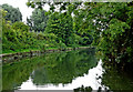
Grand Union Canal/Soar Navigation in Leicester
This is a late 19th century canalised section of the Grand Union Canal/Soar Navigation south-west of and approaching Belgrave Lock, No 44 and a confluence with the original river course. The canal here is level with the nearby River Soar (off to the left past Frog Island) so is prone to slight flooding when the river is high. Drainage is over the weir by Belgrave Lock.
The derelict industrial buildings ahead have since been demolished.
Jo Turner and N. Chadwick have noted:
Image: © Roger Kidd
Taken: 25 Aug 2013
0.02 miles
8
The Grand Union Canal
Wolsey Island on the right.
Image: © Jonathan Thacker
Taken: 2 Mar 2023
0.02 miles
9
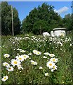
Wild Flowers at Abbey Meadows
Nature is reclaiming an industrial wasteland of recently demolished factories.
Image: © Mat Fascione
Taken: 30 May 2010
0.03 miles
10
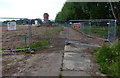
Closed footpath at the Abbey Meadows
The Abbey Meadows was the site of the former Wolsey Factory which quit the site in 2004, a water tower and chimney are all that remain.
There are plans to build 92 houses and 96 apartments in this 5.6 acre area known as Wolsey Island.
Image: © Mat Fascione
Taken: 27 May 2017
0.03 miles