IMAGES TAKEN NEAR TO
Sibson Road, LEICESTER, LE4 4NA
Introduction
This page details the photographs taken nearby to Sibson Road, LE4 4NA by members of the Geograph project.
The Geograph project started in 2005 with the aim of publishing, organising and preserving representative images for every square kilometre of Great Britain, Ireland and the Isle of Man.

There are currently over 7.5m images from over14,400 individuals and you can help contribute to the project by visiting https://www.geograph.org.uk
Image Map
Images are licensed for reuse under creativecommons.org/licenses/by-sa/2.0
Notes
- Clicking on the map will re-center to the selected point.
- The higher the marker number, the further away the image location is from the centre of the postcode.
Image Listing (27 Images Found)
Images are licensed for reuse under creativecommons.org/licenses/by-sa/2.0
Image
Details
Distance
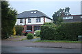
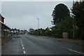
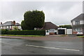
3
The Wayne Way at the corner of Sibson Road, Birstall
I am hoping for an identification of who Wayne is.
Image: © David Howard
Taken: 5 Jun 2022
0.04 miles
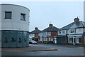
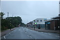
5
Junction of the Wayne Way and Sibsons Road
Image: © Wesley Trevor Johnston
Taken: 11 Oct 2007
0.05 miles
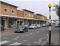
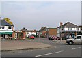
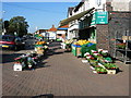
7
Shops at West end of Sibsons Road
Image: © Wesley Trevor Johnston
Taken: 11 Oct 2007
0.06 miles
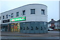
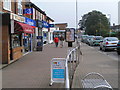
10
Sibson Road, Birstall, near Leicester
Sibson Road is the busy main shopping street of the large village of Birstall, about 4 miles from the centre of Leicester. http://www.birstall.org/ for information
Image: © Kate Jewell
Taken: 27 Oct 2005
0.09 miles