IMAGES TAKEN NEAR TO
Curzon Avenue, LEICESTER, LE4 4AG
Introduction
This page details the photographs taken nearby to Curzon Avenue, LE4 4AG by members of the Geograph project.
The Geograph project started in 2005 with the aim of publishing, organising and preserving representative images for every square kilometre of Great Britain, Ireland and the Isle of Man.

There are currently over 7.5m images from over14,400 individuals and you can help contribute to the project by visiting https://www.geograph.org.uk
Image Map
Images are licensed for reuse under creativecommons.org/licenses/by-sa/2.0
Notes
- Clicking on the map will re-center to the selected point.
- The higher the marker number, the further away the image location is from the centre of the postcode.
Image Listing (9 Images Found)
Images are licensed for reuse under creativecommons.org/licenses/by-sa/2.0
Image
Details
Distance
1
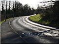
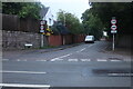
Birstall Road in Birstall
Heading towards Red Hill Circle.
Image: © Mat Fascione
Taken: 19 Feb 2012
0.13 miles
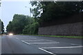
5
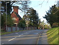
Park Road, Birstall
From Loughborough Road
Image: © David Howard
Taken: 5 Jun 2022
0.20 miles
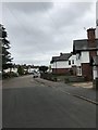
7
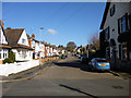
Roman Road, Birstall
A residential road, in this southern part in existence on late Victorian maps, but no indication it was anything to do with the Romans.
Image: © Robin Webster
Taken: 25 Mar 2016
0.22 miles
8
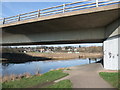
Birstall beneath Watermead Bridge
With Cycle Route 6 alongside the River Soar
Image: © Tim Heaton
Taken: 26 Feb 2012
0.23 miles
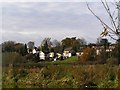
9
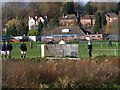
The Co-op Playing fields at Birstall
The playing fields are frequently under water as this is part of the flood plain.
Image: © Wesley Trevor Johnston
Taken: 25 Nov 2007
0.25 miles