IMAGES TAKEN NEAR TO
Greengate Lane, LEICESTER, LE4 3JF
Introduction
This page details the photographs taken nearby to Greengate Lane, LE4 3JF by members of the Geograph project.
The Geograph project started in 2005 with the aim of publishing, organising and preserving representative images for every square kilometre of Great Britain, Ireland and the Isle of Man.

There are currently over 7.5m images from over14,400 individuals and you can help contribute to the project by visiting https://www.geograph.org.uk
Image Map (Loading...)


Getting Data...Please wait
Leaflet Map data © OpenStreetMap
Images are licensed for reuse under creativecommons.org/licenses/by-sa/2.0
Notes
- Clicking on the map will re-center to the selected point.
- The higher the marker number, the further away the image location is from the centre of the postcode.
Image Listing (23 Images Found)
Images are licensed for reuse under creativecommons.org/licenses/by-sa/2.0
Image
Details
Distance
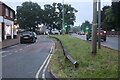
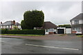
1
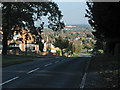
Greengate Lane, Birstall near Leicester
Looking east across the square from the Cemetery gates. The easting is just in front of the building with the white gables in the centre of the photograph.
Image: © Kate Jewell
Taken: 27 Oct 2005
0.06 miles
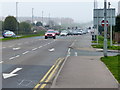
2
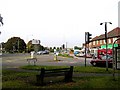
Junction of Sibson Road and Loughborough Road (A6)
Image: © Wesley Trevor Johnston
Taken: 11 Oct 2007
0.11 miles
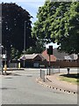
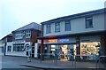
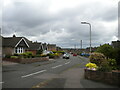
5
Service road on Loughborough Road, Birstall
Image: © David Howard
Taken: 5 Jun 2022
0.13 miles
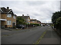
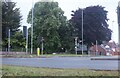
10
Wellgate Avenue, Birstall
Off Ambergate Drive.
Image: © Richard Vince
Taken: 19 Jun 2021
0.16 miles