IMAGES TAKEN NEAR TO
Saltersgate Drive, LEICESTER, LE4 3FH
Introduction
This page details the photographs taken nearby to Saltersgate Drive, LE4 3FH by members of the Geograph project.
The Geograph project started in 2005 with the aim of publishing, organising and preserving representative images for every square kilometre of Great Britain, Ireland and the Isle of Man.

There are currently over 7.5m images from over14,400 individuals and you can help contribute to the project by visiting https://www.geograph.org.uk
Image Map (Loading...)


Getting Data...Please wait
Leaflet Map data © OpenStreetMap
Images are licensed for reuse under creativecommons.org/licenses/by-sa/2.0
Notes
- Clicking on the map will re-center to the selected point.
- The higher the marker number, the further away the image location is from the centre of the postcode.
Image Listing (30 Images Found)
Images are licensed for reuse under creativecommons.org/licenses/by-sa/2.0
Image
Details
Distance
1
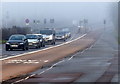
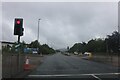
A foggy day on the A6 Loughborough Road
This stretch of the A6 dual carriageway is in Birstall, the cars are heading south towards Leicester city.
Image: © Mat Fascione
Taken: 4 Jan 2015
0.04 miles
2
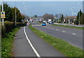
Footpath and cycleway along the A6 Loughborough Road
Heading north through Birstall.
Image: © Mat Fascione
Taken: 6 Apr 2015
0.04 miles
3
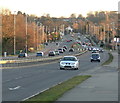
A6 Loughborough Road
Heading into Birstall.
Image: © Mat Fascione
Taken: 19 Feb 2012
0.05 miles
4
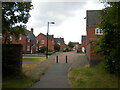
East end of Far Pastures Road, Birstall
Accessible to pedestrians along this short path, which branches off a longer one that circumnavigates a pond behind the photographer.
Image: © Richard Vince
Taken: 19 Jun 2021
0.10 miles

7
Wellgate Avenue, Birstall
Off Ambergate Drive.
Image: © Richard Vince
Taken: 19 Jun 2021
0.15 miles
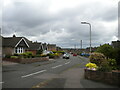
8
Harrowgate Drive, Birstall
Seen from the end of Ambergate Drive.
Image: © Richard Vince
Taken: 19 Jun 2021
0.16 miles
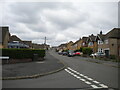
9

Little Connery Leys, Birstall
Off Hallam Fields Road.
Image: © Richard Vince
Taken: 19 Jun 2021
0.16 miles
10
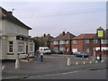
The Trees Public House
The name derives from the surrounding residential streets which are named Sycamore,Hazel,Rosetree,Maple,Myrtle,etc.
Image: © Wesley Trevor Johnston
Taken: 11 Oct 2007
0.17 miles