IMAGES TAKEN NEAR TO
Broadgate Close, LEICESTER, LE4 3FA
Introduction
This page details the photographs taken nearby to Broadgate Close, LE4 3FA by members of the Geograph project.
The Geograph project started in 2005 with the aim of publishing, organising and preserving representative images for every square kilometre of Great Britain, Ireland and the Isle of Man.

There are currently over 7.5m images from over14,400 individuals and you can help contribute to the project by visiting https://www.geograph.org.uk
Image Map
Images are licensed for reuse under creativecommons.org/licenses/by-sa/2.0
Notes
- Clicking on the map will re-center to the selected point.
- The higher the marker number, the further away the image location is from the centre of the postcode.
Image Listing (29 Images Found)
Images are licensed for reuse under creativecommons.org/licenses/by-sa/2.0
Image
Details
Distance
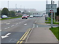
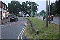
1
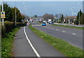
Footpath and cycleway along the A6 Loughborough Road
Heading north through Birstall.
Image: © Mat Fascione
Taken: 6 Apr 2015
0.08 miles
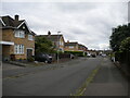
2
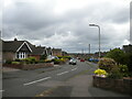
Wellgate Avenue, Birstall
Off Ambergate Drive.
Image: © Richard Vince
Taken: 19 Jun 2021
0.09 miles
3
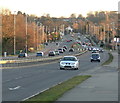
A6 Loughborough Road
Heading into Birstall.
Image: © Mat Fascione
Taken: 19 Feb 2012
0.10 miles
5
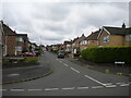
Denegate Avenue, Birstall
Off Ambergate Drive.
Image: © Richard Vince
Taken: 19 Jun 2021
0.12 miles
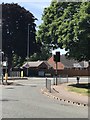
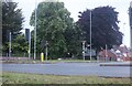
8
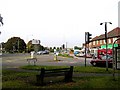
Junction of Sibson Road and Loughborough Road (A6)
Image: © Wesley Trevor Johnston
Taken: 11 Oct 2007
0.13 miles
9
Service road on Loughborough Road, Birstall
Image: © David Howard
Taken: 5 Jun 2022
0.14 miles