IMAGES TAKEN NEAR TO
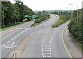
Loughborough Road, LEICESTER, LE4 3EX
Introduction
This page details the photographs taken nearby to Loughborough Road, LE4 3EX by members of the Geograph project.
The Geograph project started in 2005 with the aim of publishing, organising and preserving representative images for every square kilometre of Great Britain, Ireland and the Isle of Man.

There are currently over 7.5m images from over14,400 individuals and you can help contribute to the project by visiting https://www.geograph.org.uk
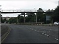
Image Map
Images are licensed for reuse under creativecommons.org/licenses/by-sa/2.0
Notes
- Clicking on the map will re-center to the selected point.
- The higher the marker number, the further away the image location is from the centre of the postcode.
Image Listing (106 Images Found)
Images are licensed for reuse under creativecommons.org/licenses/by-sa/2.0
Image
Details
Distance
1
Red Hill Way, Leicester
Viewed from the footbridge across the road.
Image: © Mat Fascione
Taken: 3 Sep 2007
0.05 miles
2
Redhill Circle, Belgrave, Leicester
Leicester's Inner Ring Road crossing the A6
Image: © Tim Heaton
Taken: 18 Dec 2022
0.07 miles
3
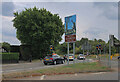
Welcome to Leicester - road version
The junction of the A6 Loughborough Road with Red Hill Circle, including a 'Welcome to Leicester' sign, similar in intent, but of different design, to the greeting extended to rail passengers in Image
Image: © Paul Harrop
Taken: 3 Sep 2022
0.09 miles
4
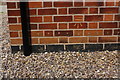
Benchmark on #365 Loughborough Road
Ordnance Survey cut mark benchmark described on the Bench Mark Database at https://www.bench-marks.org.uk/bm102288
Image: © Roger Templeman
Taken: 9 May 2018
0.09 miles
5
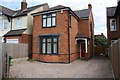
#365 Loughborough Road
There is an OS benchmark Image on the side of the house near its front corner
Image: © Roger Templeman
Taken: 9 May 2018
0.09 miles
6
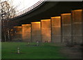
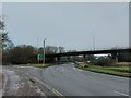
Red Hill Circle flyover
The A563 Watermead Way crosses the A6 Loughborough Road.
Image: © Mat Fascione
Taken: 19 Feb 2012
0.09 miles
7
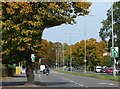
Autumn colours along the A6 Loughborough Road
Image: © Mat Fascione
Taken: 24 Sep 2017
0.11 miles
8
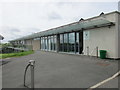
Greenacres near Birstall
A former community centre now being developed as a skills training centre by the Great Central Railway.
Image: © Jonathan Thacker
Taken: 20 May 2016
0.11 miles
10
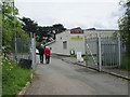
The entrance to Greenacres
There are two buildings at Greenacres. One is The Platform Cafe and the other is a training facility for the Great Central Railway.
Image: © Jonathan Thacker
Taken: 20 May 2016
0.12 miles