IMAGES TAKEN NEAR TO
Benskins Oval, LEICESTER, LE4 2HT
Introduction
This page details the photographs taken nearby to Benskins Oval, LE4 2HT by members of the Geograph project.
The Geograph project started in 2005 with the aim of publishing, organising and preserving representative images for every square kilometre of Great Britain, Ireland and the Isle of Man.

There are currently over 7.5m images from over14,400 individuals and you can help contribute to the project by visiting https://www.geograph.org.uk
Image Map
Images are licensed for reuse under creativecommons.org/licenses/by-sa/2.0
Notes
- Clicking on the map will re-center to the selected point.
- The higher the marker number, the further away the image location is from the centre of the postcode.
Image Listing (6 Images Found)
Images are licensed for reuse under creativecommons.org/licenses/by-sa/2.0
Image
Details
Distance
1
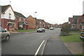
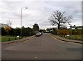
Taverners Road, near Thurcaston
This small area of residential development will become the southern edge of "Ashton Green". Compare with Image which will be on the north of the same estate.
Image: © Kate Jewell
Taken: 20 Dec 2005
0.14 miles
4
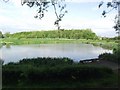
Bennion Pool, Leicester
A small fishing pool located just off Bennion Road in Beaumont Leys, Leicester.
Image: © Mat Fascione
Taken: 5 Apr 2007
0.23 miles
6
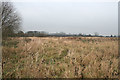
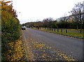
Rough pasture near Thurcaston
This land off Bevan Road is ear marked for a major residential development to be known as Ashton Green.
Image: © Kate Jewell
Taken: 20 Dec 2005
0.25 miles