IMAGES TAKEN NEAR TO
Bretton Walk, LEICESTER, LE4 2FT
Introduction
This page details the photographs taken nearby to Bretton Walk, LE4 2FT by members of the Geograph project.
The Geograph project started in 2005 with the aim of publishing, organising and preserving representative images for every square kilometre of Great Britain, Ireland and the Isle of Man.

There are currently over 7.5m images from over14,400 individuals and you can help contribute to the project by visiting https://www.geograph.org.uk
Image Map
Images are licensed for reuse under creativecommons.org/licenses/by-sa/2.0
Notes
- Clicking on the map will re-center to the selected point.
- The higher the marker number, the further away the image location is from the centre of the postcode.
Image Listing (14 Images Found)
Images are licensed for reuse under creativecommons.org/licenses/by-sa/2.0
Image
Details
Distance
1
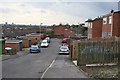
Chilcombe Close, Stocking Farm, Leicester
The centre of Stocking Farm is approximately 90 metres above sea level and there are fantastic views east, across the city centre.
Image: © Kate Jewell
Taken: 8 Nov 2005
0.14 miles
2
St Luke's Parish Church
Along Halifax Drive in the Stocking Farm area of Leicester.
Image: © Mat Fascione
Taken: 5 Feb 2017
0.16 miles
3

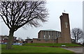
View across the Leicester city skyline
On the left is the National Space Centre.
Image: © Mat Fascione
Taken: 5 Feb 2017
0.16 miles
4
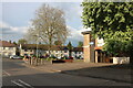
Parker Drive at the junction of Beaumont Leys Lane
Burton McCall on the right are a sales and marketing company. https://www.burton-mccall.co.uk/
Image: © David Howard
Taken: 28 Apr 2024
0.17 miles
5
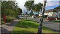
Marwood Road in Stocking Farm, Leicester
Image: © Mat Fascione
Taken: 18 Aug 2017
0.17 miles
6
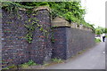
Remains of former railway bridge, Beaumont Leys Lane
There is an OS benchmark Image on the right hand face of the buttress
Image: © Roger Templeman
Taken: 9 May 2018
0.18 miles
7
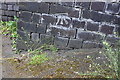
Benchmark on former railway bridge buttress, Beaumont Leys Lane
Ordnance Survey cut mark benchmark described on the Bench Mark Database at https://www.bench-marks.org.uk/bm102372
Image: © Roger Templeman
Taken: 9 May 2018
0.19 miles
8
Halifax Drive in Stocking Farm, Leicester
Image: © Mat Fascione
Taken: 5 Feb 2017
0.19 miles
9
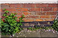
Benchmark on #35 Beaumont Leys Lane
Ordnance Survey cut mark benchmark described on the Bench Mark Database at https://www.bench-marks.org.uk/bm102373
Image: © Roger Templeman
Taken: 9 May 2018
0.21 miles
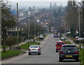
10
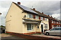
Houses on Beaumont Leys Lane
There is an OS benchmark Image on the side of the nearest house (#35) near its front corner
Image: © Roger Templeman
Taken: 9 May 2018
0.21 miles