IMAGES TAKEN NEAR TO
Pinewood Close, LEICESTER, LE4 1ER
Introduction
This page details the photographs taken nearby to Pinewood Close, LE4 1ER by members of the Geograph project.
The Geograph project started in 2005 with the aim of publishing, organising and preserving representative images for every square kilometre of Great Britain, Ireland and the Isle of Man.

There are currently over 7.5m images from over14,400 individuals and you can help contribute to the project by visiting https://www.geograph.org.uk
Image Map (Loading...)


Getting Data...Please wait
Leaflet Map data © OpenStreetMap
Images are licensed for reuse under creativecommons.org/licenses/by-sa/2.0
Notes
- Clicking on the map will re-center to the selected point.
- The higher the marker number, the further away the image location is from the centre of the postcode.
Image Listing (16 Images Found)
Images are licensed for reuse under creativecommons.org/licenses/by-sa/2.0
Image
Details
Distance
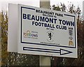
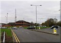
1
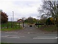
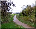
Entrance to Beaumont Town Football Club
Image: © Andrew Tatlow
Taken: 13 Nov 2012
0.07 miles
2
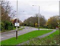
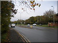
Bennion Road
Astill Lodge Road is to the right.
Image: © Andrew Tatlow
Taken: 13 Nov 2012
0.07 miles
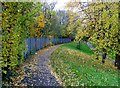
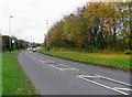
6
West end of Beaumont Way, Beaumont Leys
Image: © Richard Vince
Taken: 16 Oct 2018
0.16 miles
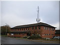
8
Beaumont Leys police station and roundabout on Bennion Road
Image: © Andrew Tatlow
Taken: 13 Nov 2012
0.17 miles
9

Flume rides at Leys Leisure Centre, Beaumont Leys
Image: © John Welford
Taken: 13 Apr 2015
0.18 miles