IMAGES TAKEN NEAR TO
Beaumont Lodge Road, LEICESTER, LE4 1BT
Introduction
This page details the photographs taken nearby to Beaumont Lodge Road, LE4 1BT by members of the Geograph project.
The Geograph project started in 2005 with the aim of publishing, organising and preserving representative images for every square kilometre of Great Britain, Ireland and the Isle of Man.

There are currently over 7.5m images from over14,400 individuals and you can help contribute to the project by visiting https://www.geograph.org.uk
Image Map
Images are licensed for reuse under creativecommons.org/licenses/by-sa/2.0
Notes
- Clicking on the map will re-center to the selected point.
- The higher the marker number, the further away the image location is from the centre of the postcode.
Image Listing (14 Images Found)
Images are licensed for reuse under creativecommons.org/licenses/by-sa/2.0
Image
Details
Distance
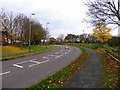
1
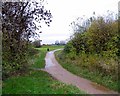
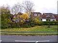
Laithwaite Close, Leicester
Behind the fence, a small enclosed group of houses. The path goes down by the side of a lawned area surrounded by trees.
Image: © Kate Jewell
Taken: 8 Nov 2005
0.05 miles
2
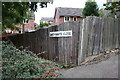
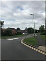
Beaumont Lodge, Leicester
On the site of Astill Farm this is a small, attractively laid out estate to the north of the outer ring road and Beaumont Leys. The houses here are in Pankhurst Road.
Image: © Kate Jewell
Taken: 8 Nov 2005
0.08 miles
4
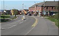
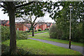
Shops on Astill Lodge Road, Beaumont Leys, Leicester
Image: © Mat Fascione
Taken: 5 Apr 2007
0.20 miles
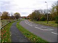
9
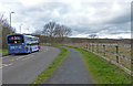
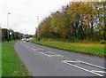
Bus on Astill Lodge Road, Leicester
This road is on the northern edge of Leicester, next to the Castle Hill Country Park.
Image: © Mat Fascione
Taken: 22 Feb 2017
0.22 miles