IMAGES TAKEN NEAR TO
Tollwell Road, LEICESTER, LE4 1BR
Introduction
This page details the photographs taken nearby to Tollwell Road, LE4 1BR by members of the Geograph project.
The Geograph project started in 2005 with the aim of publishing, organising and preserving representative images for every square kilometre of Great Britain, Ireland and the Isle of Man.

There are currently over 7.5m images from over14,400 individuals and you can help contribute to the project by visiting https://www.geograph.org.uk
Image Map
Images are licensed for reuse under creativecommons.org/licenses/by-sa/2.0
Notes
- Clicking on the map will re-center to the selected point.
- The higher the marker number, the further away the image location is from the centre of the postcode.
Image Listing (9 Images Found)
Images are licensed for reuse under creativecommons.org/licenses/by-sa/2.0
Image
Details
Distance
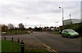
1
Leycroft Road, Leicester
This road is the main artery through several large industrial estates which spread into the next square west.
Image: © Kate Jewell
Taken: 8 Nov 2005
0.09 miles
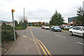
4
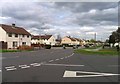
Holderness Road
Belgrave Boulevard is to the right.
Image: © Andrew Tatlow
Taken: 3 May 2013
0.21 miles
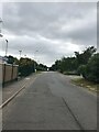
5
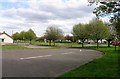
Belgrave Boulevard
Redhill Way is beyond the trees.
Image: © Andrew Tatlow
Taken: 3 May 2013
0.22 miles
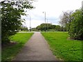
7
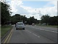
Red Hill Way nearing Beaumont Leys Lane
Red Hill Way ends at the roundabout, becoming Krefeld Way. The A563 route number continues.
Image: © Peter Whatley
Taken: 28 Jul 2013
0.22 miles
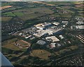
8
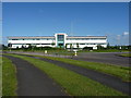
Guess whose offices these are...
Yep - Office Depot. Well done. The office building fronts a large distribution warehouse which opens onto the nearby Hoods Close.
Image: © Richard Law
Taken: 22 May 2013
0.23 miles