IMAGES TAKEN NEAR TO
Astill Lodge Road, LEICESTER, LE4 1BE
Introduction
This page details the photographs taken nearby to Astill Lodge Road, LE4 1BE by members of the Geograph project.
The Geograph project started in 2005 with the aim of publishing, organising and preserving representative images for every square kilometre of Great Britain, Ireland and the Isle of Man.

There are currently over 7.5m images from over14,400 individuals and you can help contribute to the project by visiting https://www.geograph.org.uk
Image Map
Images are licensed for reuse under creativecommons.org/licenses/by-sa/2.0
Notes
- Clicking on the map will re-center to the selected point.
- The higher the marker number, the further away the image location is from the centre of the postcode.
Image Listing (15 Images Found)
Images are licensed for reuse under creativecommons.org/licenses/by-sa/2.0
Image
Details
Distance
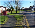
1
Mini-roundabout on Astill Lodge Road
At the junction with Maplewell Drive.
Image: © Mat Fascione
Taken: 22 Feb 2014
0.07 miles
2
Blackthorn Drive, Anstey Hill, Leicester
Imaginative housing estate adjoining Castle Hill Country Park.
Image: © Kate Jewell
Taken: 14 Nov 2005
0.13 miles
4

Astill Lodge Road/Sharpley Drive junction
Image: © Andrew Tatlow
Taken: 13 Nov 2012
0.17 miles
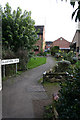
5
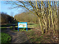
Astill Lodge entrance to the Castle Hill Country Park
Image: © Mat Fascione
Taken: 22 Feb 2014
0.17 miles
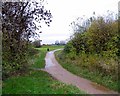
6
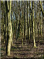
Woodland at the Castle Hill Country Park
Image: © Mat Fascione
Taken: 22 Feb 2014
0.18 miles
7

The 'Great Oak'
A survivor of the former Beaumont Leys Parkland, the tree is probably 300-400 years old.
Image: © Mat Fascione
Taken: 22 Feb 2017
0.19 miles
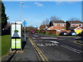
8
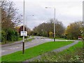
Bennion Road
Astill Lodge Road is to the right.
Image: © Andrew Tatlow
Taken: 13 Nov 2012
0.19 miles