IMAGES TAKEN NEAR TO
Kelbrook Close, LEICESTER, LE4 0US
Introduction
This page details the photographs taken nearby to Kelbrook Close, LE4 0US by members of the Geograph project.
The Geograph project started in 2005 with the aim of publishing, organising and preserving representative images for every square kilometre of Great Britain, Ireland and the Isle of Man.

There are currently over 7.5m images from over14,400 individuals and you can help contribute to the project by visiting https://www.geograph.org.uk
Image Map
Images are licensed for reuse under creativecommons.org/licenses/by-sa/2.0
Notes
- Clicking on the map will re-center to the selected point.
- The higher the marker number, the further away the image location is from the centre of the postcode.
Image Listing (3 Images Found)
Images are licensed for reuse under creativecommons.org/licenses/by-sa/2.0
Image
Details
Distance
1
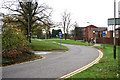
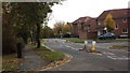
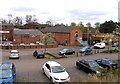
Tilling Road, Beaumont Leys, Leicester
Well designed in the 70s and 80s, with cul-de-sacs linked by footpaths running across large landscaped areas, this part of the vast Beaumont Leys estate still has a run down feel.
Image: © Kate Jewell
Taken: 8 Nov 2005
0.15 miles