IMAGES TAKEN NEAR TO
Darenth Drive, LEICESTER, LE4 0PJ
Introduction
This page details the photographs taken nearby to Darenth Drive, LE4 0PJ by members of the Geograph project.
The Geograph project started in 2005 with the aim of publishing, organising and preserving representative images for every square kilometre of Great Britain, Ireland and the Isle of Man.

There are currently over 7.5m images from over14,400 individuals and you can help contribute to the project by visiting https://www.geograph.org.uk
Image Map (Loading...)


Getting Data...Please wait
Leaflet Map data © OpenStreetMap
Images are licensed for reuse under creativecommons.org/licenses/by-sa/2.0
Notes
- Clicking on the map will re-center to the selected point.
- The higher the marker number, the further away the image location is from the centre of the postcode.
Image Listing (12 Images Found)
Images are licensed for reuse under creativecommons.org/licenses/by-sa/2.0
Image
Details
Distance
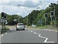
1
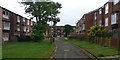
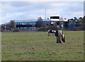
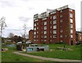
Upper Temple Walk in Beaumont Leys, Leicester
Image: © Mat Fascione
Taken: 30 Jul 2019
0.09 miles
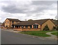
2
Gilroes Reservoir
A former Leicester Corporation covered reservoir at Severn Trent Water's Leicester Water Centre.
Image: © Ian Calderwood
Taken: 7 Jul 2023
0.16 miles
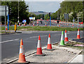
4
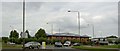
Gala bingo building on the busy A563 Leicester
Image: © Steve Fareham
Taken: 23 Jul 2008
0.17 miles
5
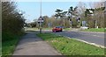
Looking northwest along Anstey Lane, Leicester.
Image: © Mat Fascione
Taken: 1 Apr 2007
0.18 miles
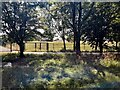
9
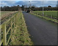
Footpath and cycleway near Leicester Frith Farm
The line of trees in the distance are along the A5630 Anstey Lane.
Image: © Mat Fascione
Taken: 1 Jan 2013
0.23 miles