IMAGES TAKEN NEAR TO
Sheringham Road, LEICESTER, LE4 0JQ
Introduction
This page details the photographs taken nearby to Sheringham Road, LE4 0JQ by members of the Geograph project.
The Geograph project started in 2005 with the aim of publishing, organising and preserving representative images for every square kilometre of Great Britain, Ireland and the Isle of Man.

There are currently over 7.5m images from over14,400 individuals and you can help contribute to the project by visiting https://www.geograph.org.uk
Image Map
Images are licensed for reuse under creativecommons.org/licenses/by-sa/2.0
Notes
- Clicking on the map will re-center to the selected point.
- The higher the marker number, the further away the image location is from the centre of the postcode.
Image Listing (12 Images Found)
Images are licensed for reuse under creativecommons.org/licenses/by-sa/2.0
Image
Details
Distance
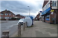
2
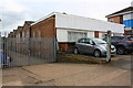
#105 Parker Drive at Stadium Place junction
Premises of OSS Electrical Services with OS benchmark Image at the back of the right hand face
Image: © Roger Templeman
Taken: 9 May 2018
0.15 miles
3
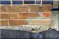
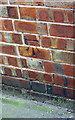
Benchmark on #105 Parker Drive
Ordnance Survey cut mark benchmark described on the Bench Mark Database at https://www.bench-marks.org.uk/bm102292
Image: © Roger Templeman
Taken: 9 May 2018
0.15 miles
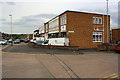
4
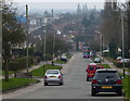
Parker Drive in Leicester
A road with a mix of houses and factories.
Image: © Mat Fascione
Taken: 18 Aug 2017
0.16 miles
5
W Brewin & Co Ltd's factory, 145 Parker Drive
Company specialising in children's hosiery. There is an OS benchmark Image on the side of the building near its front corner and visible through the metal gate
Image: © Roger Templeman
Taken: 9 May 2018
0.18 miles
6
Benchmark on #145 Parker Drive, W Brewin & Co Ltd
Ordnance Survey cut mark benchmark described on the Bench Mark Database at https://www.bench-marks.org.uk/bm102371
Image: © Roger Templeman
Taken: 9 May 2018
0.18 miles
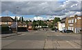
7
Halifax Drive in Stocking Farm, Leicester
Image: © Mat Fascione
Taken: 5 Feb 2017
0.21 miles
8
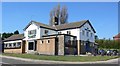
The John O Gaunt Public House
At the junction of Somerset Avenue and Wiltshire Road.
Image: © Mat Fascione
Taken: 5 Apr 2007
0.21 miles
9
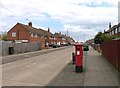
Cheltenham Road
Showing pillar box LE4 737!
Image: © Andrew Tatlow
Taken: 3 May 2013
0.22 miles
10
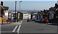
Somerset Avenue, Leicester
Photographed from its junction with Burnham Drive.
Image: © Mat Fascione
Taken: 5 Apr 2007
0.23 miles